Low Latency Product Fact Sheet | Community of Practice | Mission Updates | New Data Sets| Upcoming Meeting Sessions | ICESat-2 Visualization | Outreach Events | Research Highlights | Upcoming Conferences| Data Tools

Quarterly News and Updates

Discover the latest developments in ICESat-2 research and Applications.

Low Latency Products


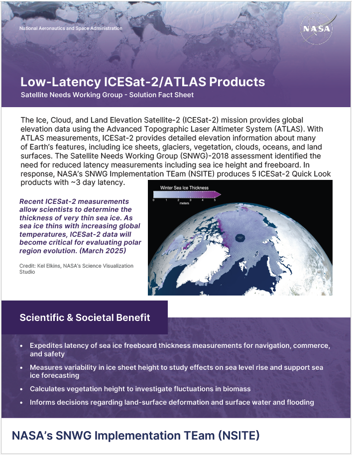
A Satellite Needs Working Group (SNWG) assessment in 2018 identified the need for reduced latency measurements including sea ice height and freeboard. In response, NASA’s SNWG Implementation TEam (NSITE) produces 5 ICESat-2 Quick Look products with ~3 day latency. Read more in the Fact Sheet linked below.


Download Fact Sheet

Untitled Design_p1.png

Community of Practice


The Applications Team will be facilitating thematic discussion groups for ICESat-2 data applications. These groups will promote conversations on how the data are applied, share ideas for future data use, provide feedback on data usability, and receive/offer support. The goal is to create communities of practice by joining researchers with common applications & interests.


To stay informed of future activities, send an email with 'subscribe' in the subject to icesat2-community-of-practice-join@lists.nasa.gov

Untitled Design_p1.png

Mission Updates & Metrics


Mission status: Nominal

Days in Orbit: 2854

Shot Count: 2408178410000

Laser is firing at level 6.


Cloud Distribution:

  • 6,754 usernames
  • 95,570,122 files
  • 144 countries

ATL03, ATL06, & ATL08 remain the most-downloaded data products.


Near Real Time (Quick Look) Products:

  • 778 registered users names
  • 226,088 files downloaded

New Data Set Releases


Are you thinking about attending the upcoming ESIP meeting either virtually or in-person in Austin, TX?


If so, we are excited to invite you to a session we are organizing titled: "Bridging human silos: Setting up data-centric Communities of Practice to reach across divides."


Session Details

  • Who: Earth science data users, researchers, and community builders
  • What: ESIP Session, "Bridging human silos"
  • When: July 29, 2026 at 08:30 CDT
  • Where: Location / Virtual Link TBA


Are you attending the upcoming AGU2026 annual meeting in San Francisco, CA?


If so, we are excited to invite you to a session we are organizing titled: "Satellite Altimetry to Drive Risk Analysis, Resilience and Adaptation."


The session invites contributions that use multisensor approaches that use altimetry data together with spaceborne lidar, optical, hyperspectral and radar to develop decision-making applications and address key challenges, including, but not limited to, sea level rise and wildfire risk.

New Visualization Alert!

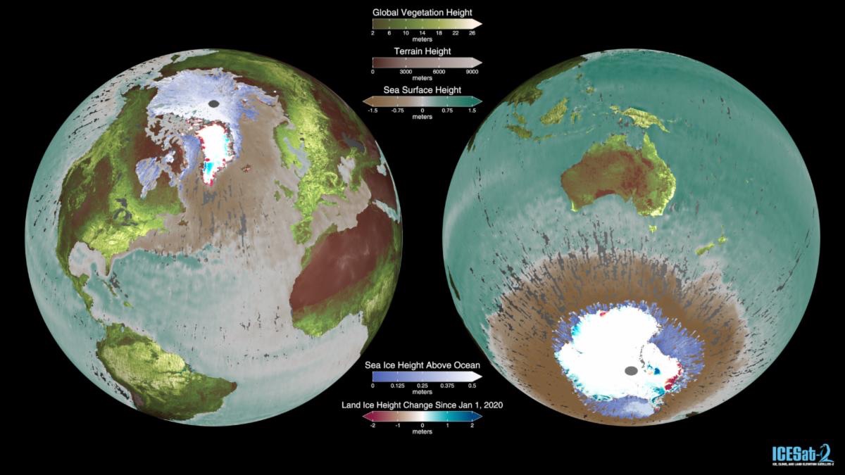
The new ICESat-2 visualization, produced by NASA Goddard Science Visualization Studio, shows several data products from NASA’s ICESat-2 mission appearing sequentially as the Earth rotates. ICESat-2’s laser altimeter measures elevation and structure across ice sheets, sea ice, oceans, forests, and clouds, providing scientists with precise observations of Earth’s changing surface and atmosphere. 

Outreach Events

ICESat-2 will be represented by Valerie Casasanto and the Girl Scouts Unite Convention at the Washington DC Convention Center July 23-25, 2026.


Stop by the ICESat-2 booth, say 'Hi' and make sure to catch Valerie's hyper wall talk 'From Penguins to Lasers: the Ice, Cloud, and land Elevation Satellite-2.'

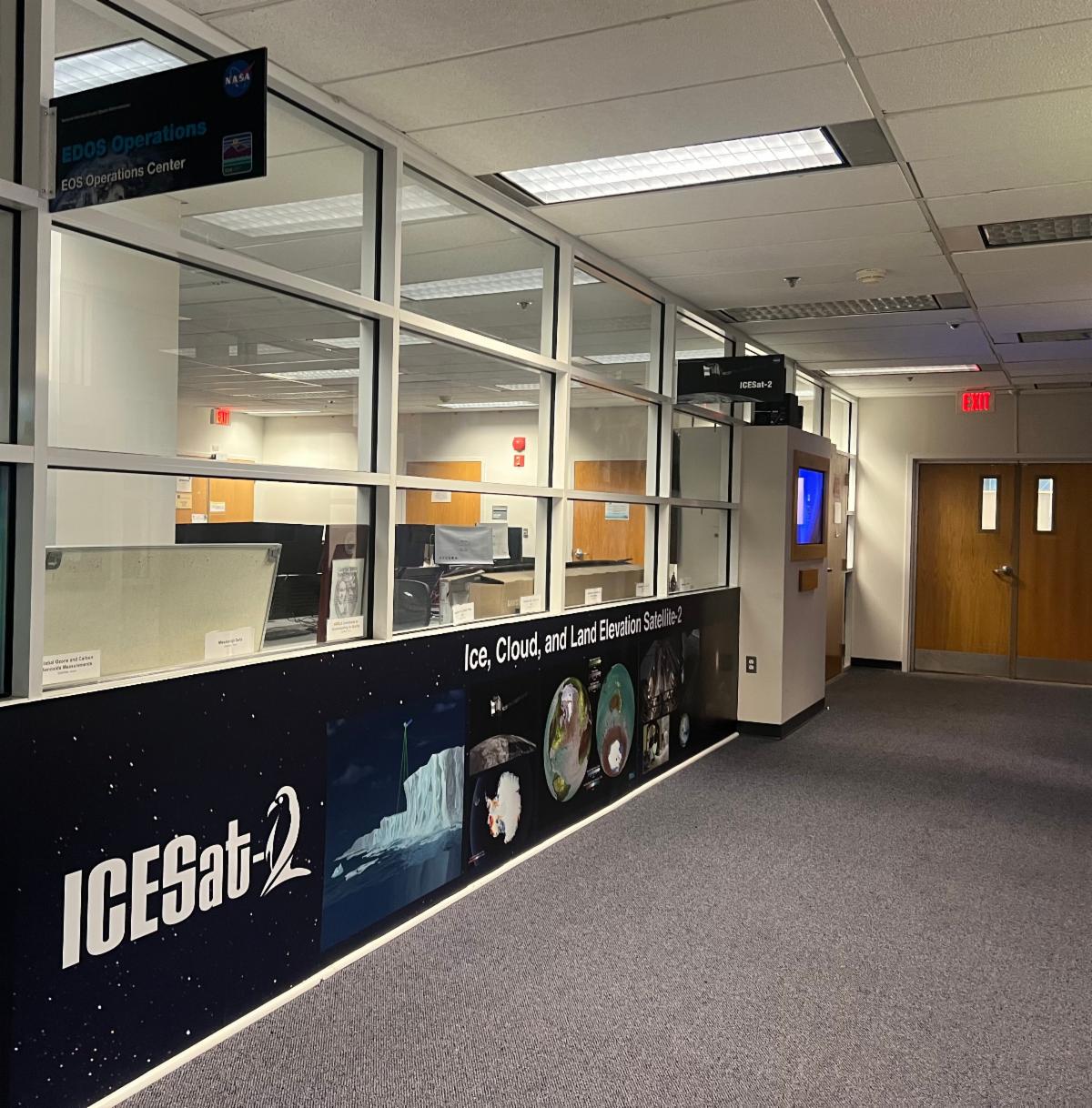
The new ICESat-2 Mission Operations Center is almost ready! Next time you are on-site at Goddard, check it out on the second floor of Building 32.


An ICESat-2 Touch Screen is in the works and will be displayed outside the mission control room The touchscreen will be available late fall and on the new ICESat-2 website (coming soon!).

Screenshot_2026-07-08_at_2.08.32_PM.png_p1.png

ESAS 2026 Decadal Survey


The National Academies of Sciences, Engineering, and Medicine is conducting "ESAS 2028," the Decadal Survey for Earth Science and Applications from Space 2028–2037. This community-based effort will develop a comprehensive strategy that builds on the 2018 decadal survey. White papers are due August 24th 2026.


Read More

Research Highlights

(Explore Zotero Library)

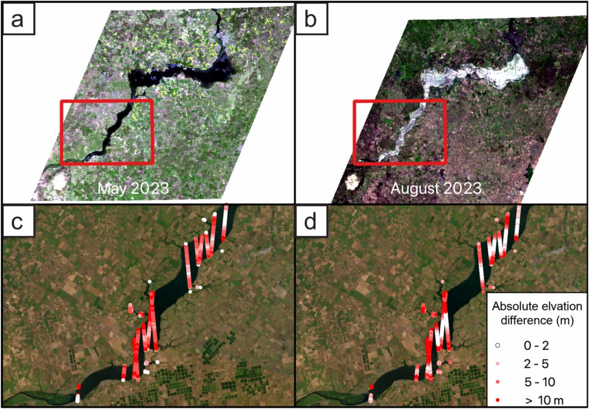
SWOT Satellite Observations of the Kakhovka Dam Break Flood Highlight Limitations of Outburst Flood Models. By Lehnigk et al. 2026 in Geophysical Research Letters.


Detailed satellite measurements of the Kakhovka Reservoir flood by SWOT reveal that even with improved topographical data, standard models still under predict flood speed and height. ATL08 was used to provide measurements not captured by SWOT.


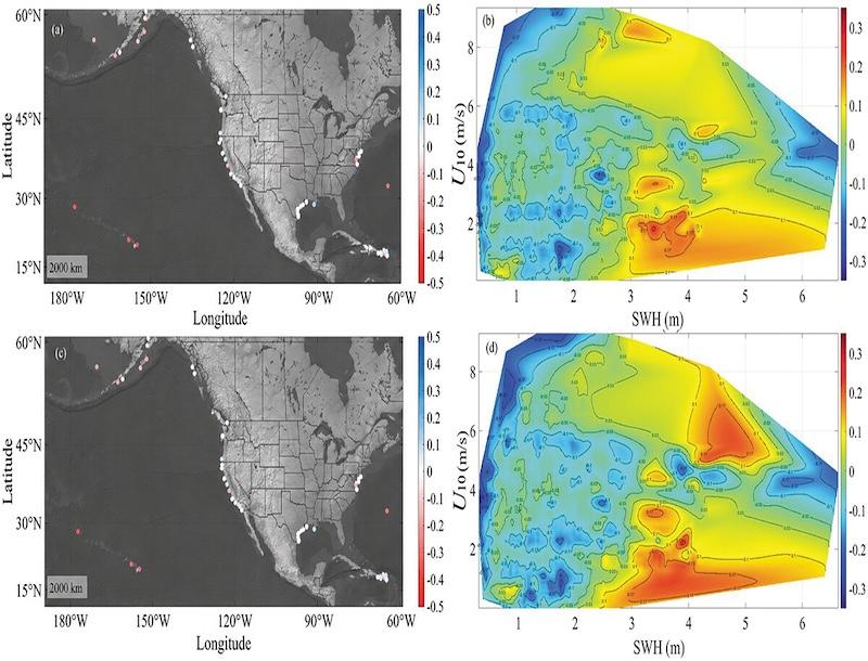
Assessment and Correction of Sea State Bias for ICESat-2 Altimetry in Coastal Areas. By Song et al. 2026 in Geo-spatial Information Science.


To address residual sea state bias in ICESat-2 coastal altimetry data, researchers developed a generalized additive model. This new model significantly reduces measurement errors, enhancing the satellite data's accuracy for shallow-water monitoring.


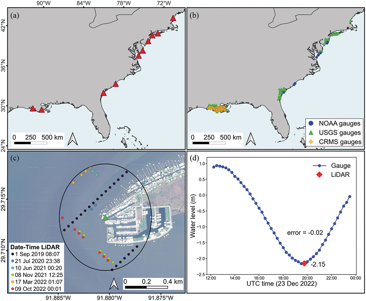
Water Level Detection in Coastal Areas with Spaceborne LiDAR: Accuracy Assessment of GEDI and ICESat-2 Data. By Parra et al. 2026 in Remote Sensing Letters.


This study found that ICESat-2 measures coastal water surface elevations more accurately than GEDI. However, GEDI's denser coverage demonstrates that spaceborne LiDAR can effectively supplement traditional water level gauges.

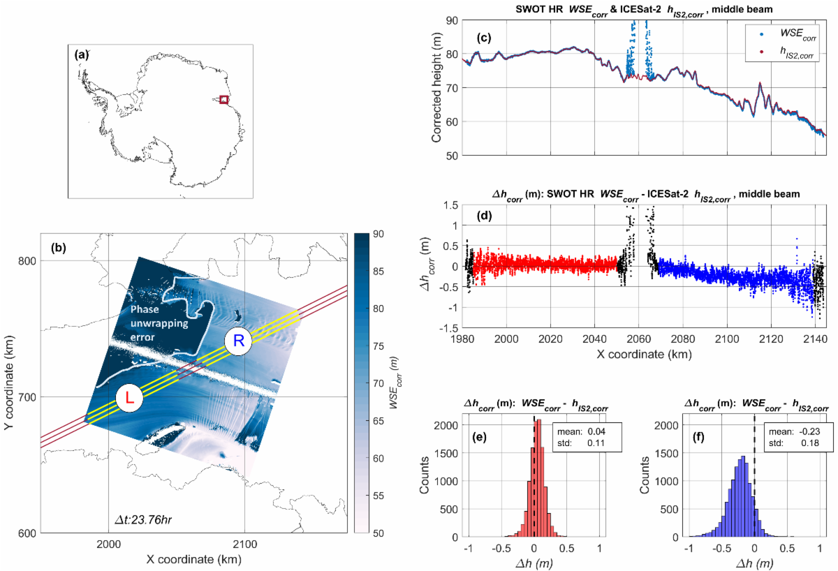
SWOT High-Rate Raster Data Reveals Antarctic Ice Shelf Motion and Change in Response to Ocean and Ice Dynamics. By Howard et el. 2026 in Geophysical Research Letters.


ICESat-2 provides critical validation data over Antarctic ice shelves for a novel application of SWOT swath mapping to ice shelf height change and motion. By interpolating the SWOT gridded data to ICESat-2 along-track locations (and making necessary corrections), we can directly compare the two missions.


(Note: Link may not be active yet)

Upcoming Meetings & Conferences

Tools and Resources

For data downloading, processing and visualization