|
Please Update Your Software From Version 6.15 to Version 6.16 | |
|
Upgrade your software through the SurvCE|PC About menu or through these download links for SurvCE or SurvPC
| |
|
SurvCE/SurvPC 6.0 was released on July 13, 2018. One of the major improvements in Version 6 was the handling of various IMU/tilt readings from GNSS equipment, most notably the readings of the Carlson BRx7 but also applying to other brands of GNSS. This allows users to tilt the pole, usually up to limits of around 30° to 40° of tilt, and record a relatively accurate position at the base of the pole. The greater the tilt, the more potential inaccuracy is introduced. Since first release, Version 6 has been updated numerous times. For example, 6.14 was released on May 5, 2022 and 6.15 was released July 8th, 2022 and appeared on our website for a brief window of 3 weeks. The current release is 6.16, released August 2, 2022. A bug was introduced when 6.15 was released and was corrected by 6.16, the current release. The 6.15 release itself led to slightly more accurate tilt results which need to be explained first.
The BRx7 IMU accuracy is rated at 2 cm at 30° of tilt and is nearly perfectly accurate at tilts of less than 10°. Using versions of SurvCE/SurvPC prior to 6.15, a Czech customer in the commonly used Czech projection Czech (JTSK-Křovák 1710), at tilts of 20° to 30°, noticed discrepancies in recorded measurements of 10 cm or more versus when configured to UTM. This particular Czech projection has a Central Meridian that is not centered to the projection coordinates but offset to one side of the country. This projection highlighted the need to apply the tilts, using the converging longitudes, to the Lat and Long values first before conversion to projection coordinates and not directly to the final coordinates based on projection North. When this was done, accuracies closely matched the UTM accuracies. This change was made in SurvCE/SurvPC 6.15 and only has meaningful impacts on stored Northing/Easting values at large tilts of 20° to 30° in locations far from the projection’s Central Meridian, and most notably at higher (or lower) latitudes. The Czech projection met all these conditions and revealed the need for these improvements in 6.15, which was released on July 8th, 2022. Here are some examples of impacts, one from Kentucky and the other from the Czech projection:
Kentucky Example, NAD83, KY Single Zone, in Feet, 40° of tilt
| 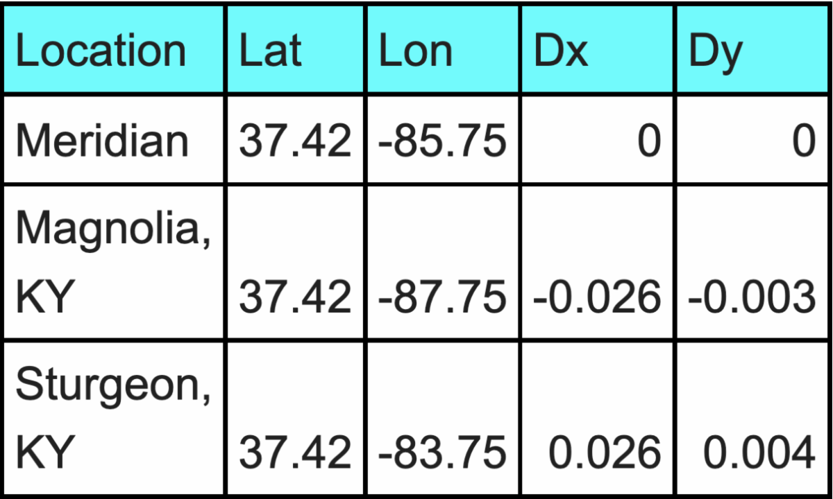 | |
The tilt computation improvements shown above (found in 6.15 and 6.16), are actually less than the error ratings of the tilt sensors at 30° and are not likely to be noticed in practice. The magnitude of the error is determined by the distance away from the Central Meridian, and the direction of the error is determined by your orientation (whether you are tilted N, S, E, or W). When the pole is leaning N or S, most of the error appears in the X direction, and when the pole is pointing E or W, most of the error is in the Y direction. In the case above, the pole is pointing roughly south, so the error is in the X direction, and flipped based on which side of the Meridian you are on. Even at the 40° of tilt, the adjustments to the calculation do not exceed 0.03 and decrease exponentially moving to 0° of tilt. At the Central Meridian, there is no impact at all to the calculations.
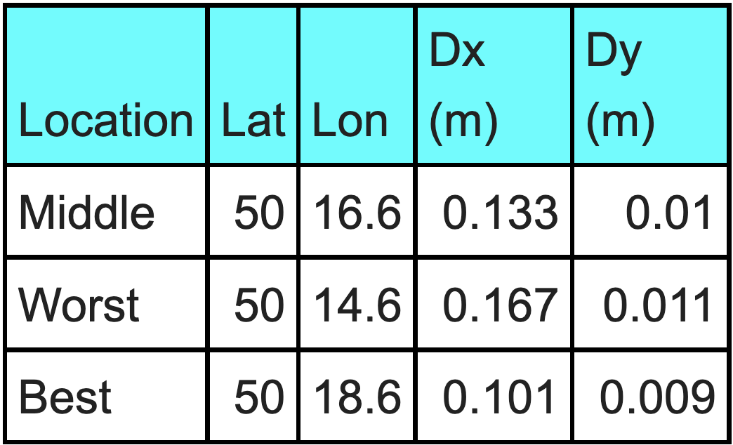
Now, switching to the Czech coordinate system -- this is a very extreme case because the origin point of the projection is actually in the Ukraine, and is not covered by the grid files we need to do the projection, so we weren't able to calculate results directly on the Meridian. This is a very wide projection. So in this case we ran the numbers at longitude 14.6, 16.6, and 18.6. The Central Meridian is all the way over at 24.833 so we expect them all to be bad, with 18.6 as the best, and 14.6 at the worst.
| |
|
From this example, the 6.15 program adjustment led to a maximum improvement of 0.167 meters or 16.7 centimeters at 40° of tilt. This would decrease dramatically at lesser tilt amounts, but it was working within this projection that revealed the need to apply the tilt impact to the Lat/Long first before converting to projection coordinates.
This improvement in Release 6.15, applying to high tilts in farther north/south latitudes at points far from the Central Meridian, introduced an error in which when tilt is turned from on to off, coordinates were stored based on recalling the last tilt measurement recorded. This was corrected in 6.16. All coordinates stored with 6.15 can be corrected by reprocessing the RW5 or raw file. The raw data is stored correctly.
The SurvCE.com website duration of this bug was from July 8th to August 2nd. From July 9th to July 28th, 6.15 was loaded on RT4 tablets shipped with the BRx7. On July 29th after the bug was first discovered by user Michael Kirkpatrick, confirmed and traced, and through August 1st, RT4s were shipped with 6.14. Starting August 2nd, RT4 tablets were shipped with 6.16 which fixed the problem, defined as follows:
- Running in Tilt Off mode exclusively, there is no problem.
- Running in Tilt On mode exclusively, there is no problem.
- Running in Tilt Off mode and converting to Tilt On mode, there is no problem.
- Specifically Running in Tilt On mode and converting to Tilt Off mode, that last tilt recorded is applied to all Tilt Off readings until power off or the program is exited. Although measurements in this condition may be positioned correctly relative to each other, the delta of the tilt would make every measurement wrong by the tilt amount of the last recorded tilt. Unless checking to a known coordinate, the errors could go unnoticed in this state.
IMU readings for tilt are impacted by float/fix conditions and need time to reset when going in and out of float. This often occurs as you go into trees and brush and experience high-multipath or low satellite conditions. The BRx7, for example, will fix in these environments, faster and more reliably than virtually all competitors based on testing, but the intermittent nature of the fix/float condition can undermine tilt performance. For this reason, many users of the BRx7 turn off tilt as they enter a wooded environment and simply take readings in the vertical position as indicated by the level bubble on the pole. So it is possible that users, accustomed to this procedure, may have turned off tilt entering woods, and subsequent measurements with the BRx7 in woods, using version 6.15, could have incorrect coordinates at the no-tilt measurements. These, however, can be corrected by re-processing the RW5 (raw) file. This issue of storing the last tilt with all no-tilt measurements, was quickly resolved after being reported, in the current 6.16 version of SurvCE/SurvPC. Version 6.16 also retains the slightly improved accuracies for high tilt readings in higher latitudes at points distant from the Central Meridian of the projections being used.
It is recommended that all user of SurvCE/SurvPC update to Version 6.16. Version 7, which includes network least squares and BIM/IFC/RVT file stakeout in the field, is scheduled for release in the September-October, 2022 time frame.
Please contact [email protected] or call us at 606-564-5028 with any questions.
| | | | | |