|
|
Recent Paintings
|
|
|
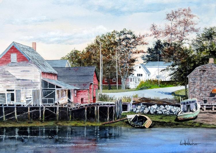
Fish Shacks ......
by Bill Hudson
Watercolor & Casein, 14" x 20"
$1,550 includes a custom frame
|
These forsaken lobster boats and harbor buildings waste away on Campobello Island in New Brunswick, Canada. The small, nine-mile-long island in the Bay of Fundy is only connected by road to nearby Lubec, Maine. The 1,000 inhabitants rely on the fishing industry and tourism to the historic summer retreat of Franklin and Eleanor Roosevelt.
The Art of Cartography
...... by Bill Hudson
While growing up in Maryland, every elementary school classroom and all high school social science classrooms had large roll-down maps hanging above the chalkboards. Teachers wanting to emphasize the location of a continent, ocean, country, city, or any other world feature, went to the roll of choice, manually pulled down on the attached string or handle, and bingo ... the world was instantly at their fingertips. My schools had the flat map of the world known as the Mercator projection and assorted individual maps of the United States, Europe, Asia and Australia, etc.
I never fully appreciated the maps or the exploration and history that went into their making until one eventful winter day in 1961 when I was a junior in high school. During a class being taught by Mr. Casciotti, an exceptional teacher who was articulating the importance of the Great or Continental Divide, my attention was worthlessly out the window where snowflakes were beginning to appear. My imagination was extrapolating the few flurries into an epic blizzard that would surely cancel school imminently. But my daydreams were shaken when Mr. Casciotti went to the map of the U.S. to visually help us understand the geographic impact of the Rocky Mountains.
He grabbed the map string, pulled down, and in milliseconds the classroom went into stop-action silence, followed by girls' gasps, then giggles, then "Wahoos" from the hormone-fueled guys. Scotch-taped dead center to the middle of the map, coincidentally adjacent to the same Rocky Mountains, was the magnificent, smiling, naked, Playmate of the Month Centerfold for February 1961. WOW !
We had joyfully transitioned into the Twilight Zone. The crude map embellishment instantly stole my interest which was now secured in geography, mountains, and human anatomy. Even Mr. Casciotti took a moment to enjoy the recent update to the Rockies. It was an act of cartographic genius! And thereafter, every student and every teacher paused with cautious anticipation before any map was pulled down.
More than a decade later I depended on, and became artistically fascinated with nautical charts. In addition to my full-time job as an aerospace engineer, I also began a commercial crabbing venture with my brother-in-law George, who like myself was also an engineer ... and thrifty. We bought a used 20-foot, deep-V, Larson inboard/outboard workboat and leased a slip in Huntington Harbor, California. To save a few bucks, we made our own crab pots, set them in waters north of Anaheim Bay and sold our catch which included several species of stone crabs, sculpin, and sablefish to a market in San Pedro and another in Santa Ana. While other local crabbers were using expensive hydraulic systems to pull their pots from depths approaching 55 fathoms, I purchased a 24-volt aircraft starter motor for $20 from the surplus store of North American Aviation, my employer. We mounted a capstan to the motor shaft, added another battery for dependable reserve power and were in the crabbing business competing with a well known Portuguese fishing family from San Pedro.
|
|
|
| My Crab Boat ... 1975 |
|
This was in the 1970's before the availability of GPS. And being "frugal" engineers, George and I did not invest in anything costly like sophisticated electronic fish-finders, depth gauges, or radio systems. We relied on accurate nautical charts to set and mark our traps. Like my father, grandfather, and cave-dwellers before them, we accurately measured depths with a rock attached to a rope. From a store in downtown San Pedro that specialized in world nautical charts we purchased depth charts of the local fishing grounds out six or seven miles to Horseshoe Kelp where the edge of the offshore shelf plunged deep into the San Pedro channel and became impractical to crab.
Also being artistically inclined and reminiscent, I purchased more charts for areas near Virginia's Chesapeake and Chincoteague Bays where my father's side of the family were all watermen. On those charts I did pen and ink drawings of Eastern Shore workboats (deadrises, skipjacks, buyboats, punts, etc.) and gave them to friends and relatives. George and I continued to crab on weekends and pay college kids to pull our pots during the week for a year or so until we realized it had to be full-time engineering or full-time crabbing, but not both. We sold the business with no regrets and a lot of great memories. And that would have been the end of my story until last month.
My wife and I just returned from our first trip to Hawaii compliments of my generous son Will and his wonderful family. I was walking the waterfront shopping district of Lahaina in Maui, enjoying the local art when I entered the Lahaina Printsellers at 764 Front Street which has the work of established Hawaiian artists in the front of the gallery and an Antique Map Gallery in the back (ref
www.printsellers.com
.) The Map Gallery run by Alyce Valenta has a large selection of original and often rare maps on paper along with many giclée reproductions on canvas of maps dating back into the 1700's. The giclées are available in many sizes at fair, affordable prices. For example, a canvas 16" x 20" "Map of the Hawaiian Group or Sandwich Islands" dated 1841, sells for $95. They also offer substantial discounts for the purchase of multiple maps. I had discussions with the owners regarding copyrights and the feasibility of painting my own images on these beautiful old maps. I also discussed overlaying images from my portfolio onto relevant areas of the existing maps and selling the reproductions. Both approaches were deemed acceptable and even encouraged since the maps were now "public domain." ¹ I then purchased six antique maps to begin the process. The maps of most interest were those maritime areas that I had already painted scenes of such as the Chesapeake Bay, Oregon, Maine, Ireland, and Massachusetts. I also purchased the 1841 map of the Sandwich Islands.
I have never forgotten how even a scotch-taped image, when well-placed and relevant, can capture an otherwise disinterested eye. I'm now anxious to begin adding my images to the already elegant art of vintage cartography.
_____________________________________________________________________________________
1. In 2014, the New York Public Library released more than 20,000 high-resolution, historical maps to the public domain. The maps are from as early as the 16th century and can be downloaded free for unlimited use by anyone.
Also, in July of this year the U.S. Geological Survey, or USGS, provided an updated service that permits public domain downloads of topographical map scans.
_____________________________________________________________________________________
Upcoming Events
Art Instructor, Laguna Beach Art League, Mondays, Jan 2018
Southwest Arts Festival Indio, Jan 25,26,27,28, 2018
Indian Wells Arts Festival, Mar 30, 31, Apr 1, 2018
|
|
|
The Mahl Bridge and Clamps (sold separately)
|
|
Retail Price: $59.99
Special: $29.99
(Free Watercolor Pocket Guide with Purchase)
|
FREE: This Newsletter is a free service. Selected announcements for individual artists and organizations are also free. Share a painting or marketing tip. In exchange Watermen Art will publish the tip, and post at least one of your images with a short bio and link to your website. Click to send us an email containing a tip or announcement.
|
|
|
|
|
|
|
|