|
Celebrating 30-years of Field Studies
by Jennifer Trask, Principal & Manager, Field Studies
| |
|
As Waterborne concludes its 30-year celebration and begins the next decade of innovation and services, we have much to celebrate and be thankful for in our Field Studies Programs. After decades in the field, we have learned a thing or two about monitoring programs! These last decades have seen us working with the most sophisticated tools, and yet sometimes, at the end of the day, make-shift MacGyver moves were the only way to successfully collect a sample. Whatever it takes!
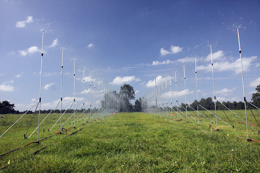
In the early years, our focus was placed on groundwater in the form of prospective and ambient monitoring studies as well as leaching studies. Despite cut wires, battery losses, wells dug, and water extractions, our greatest challenges always dealt with finding suitable sites that would meet multi-year requirements from all perspectives – sponsors, scientists, farmers, cooperators, and regulators. The investment in resources for studies of this nature required efficiencies in preparatory environmental data review, assessment, digitization, and GIS overlays and analysis well before we could embark on field investigation for suitability.
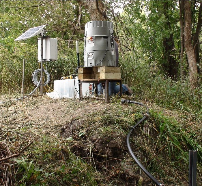
Other study specialties included crop residue and terrestrial and aquatic dissipation studies. We have relied on our ever-growing partnerships to execute studies in different parts of the US on both land- and water-based research farms. We have learned that wild animals will likely cause instrumentation issues over a longer-term study. While some critter contributions are obvious, like chewed wires and little rodent nests, others become a mystery of the study. My favorites are random, ghost-like blurs caught on game cameras as our visitor jets through the fields, only leaving the destruction of wires and soil holes as evidence that they were there. Fortunately, our remote monitoring of real-time data systems has allowed us to find these “data absence moments” and quickly act on solutions to minimize data loss...
>> Read the full article
| | |
Modern Geographic Information System (GIS) and Remote Sensing | |
|
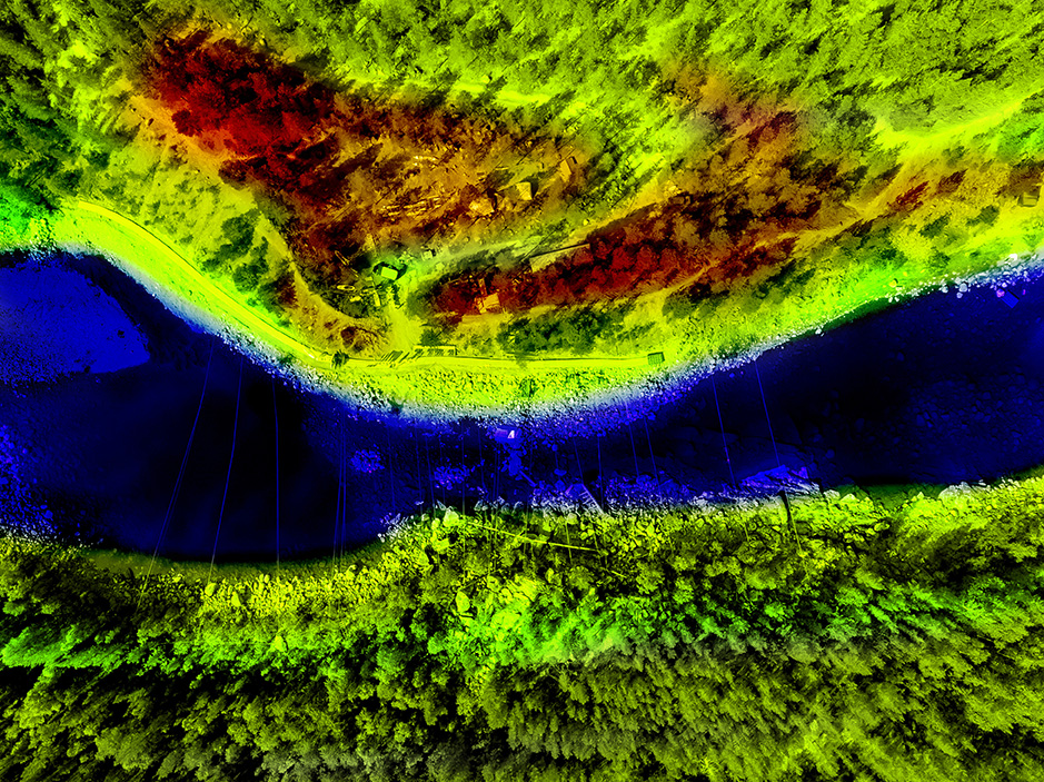
Relating geographic data, especially seemingly random or disconnected data, was once a challenging effort requiring countless hours and calculations to produce usable results. However, since Roger Tomlinson first released his groundbreaking system in 1963, scientists have had Geographic Information System (GIS) technology to capture, store, check, and display related geographic positions. Waterborne’s scientists work extensively with GIS and remotely sensed data mapping through our Spatial Analysis and Field Studies client work dealing with pesticide risk assessments, endangered species assessments, modeling, watershed characterizations, and much more.
Today’s GIS has come a long way from its early mainframe computer and line printer output roots. Modern GIS doubles down on technology to bring detailed data results previously unavailable or out-of-reach for the typical study. By acquiring the latest GIS datasets on land use, soils, weather, elevation, climate change vulnerability, threatened and endangered species habitats, Waterborne’s scientists are able to run robust and precise spatial datasets that can become the basis for specialized models. We can then apply additional layers of technology, including:
-
ESRI Software. Utilizing several of ESRI’s products, including ArcGIS Pro, ArcGIS Server, ArcGIS Online, and Survey123, Waterborne’s scientists create maps, interactive web maps, and web tools, and surveys that can be filled out while in the field or back in the lab.
-
GIS Crosswalks. We perform our own GIS crosswalks or use publicly available tools like OECD ENASGIPS. By using soil, climate, and other spatial data, we can identify similar ecoregions, perform site selection, etc.
Remote sensing has had a dramatic impact on GIS, providing new levels of technology and modeling opportunities. Waterborne’s scientists may employ...
>> Read the full article
| |
PWC3 has been released! Preliminary Observations by Amy Ritter
| |
|
The anticipation is over. US EPA released their newest version of the Pesticide Water Calculator (PWC v3.0). PWC Version 3 includes some new features and different output of results. Here are some initial observations of PWC3 from some very quick runs:
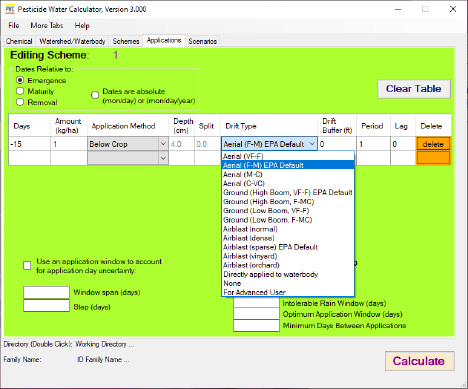
- As presented in the EMPM meeting, PWC3 now has a “scheme” tab in which the user can select multiple scenarios and an application scheme to go with the selected scenarios (as opposed to a batch file). The new application tab allows the user to choose the drift type and a buffer distance then the model populates the spray drift value for the user for both the pond and reservoir waterbody scenarios (see figure below). If the user wants to see the spray drift values used in their run, the user needs to check the box in the “optional output“ tab.
- Additionally, if the user wants a “.zts” file or old “.csv” file (now “.out” files) with daily values, the user needs to select...
>> Read the full article
| |
Beyond the Beauty: the Environmental Impact of the Rose | |
|
May is a time for roses. Between the “Run for the Roses” Kentucky Derby held on the first Saturday in May, Mother’s Day in the middle of the month, and a plethora of spring events and weddings, roses seem to be everywhere. They are beautiful; however, behind that beauty lies a complex web of environmental implications, particularly when it comes to commercial cultivation. Roses may symbolize love and passion, but their mass production can leave a not-so-rosy mark on the environment.
As consumers increasingly prioritize sustainability, rose production's environmental impact is being scrutinized. Often grown outside the United States in South America or Africa, roses are a water-intensive crop that requires irrigation systems to maintain their lush appearance. In regions where water resources are scarce, this can exacerbate local water stress and strain ecosystems. Ecuador, one of the world’s primary rose-growing locations, is currently experiencing a severe drought that is requiring water rationing in parts of its country.
Water is only the start of the commercial rose industry’s thornier side. Growing the perfect rose takes more than planting and watering; the process begins with the land itself. The expansion of commercial rose cultivation often comes at the expense of natural habitats. Large-scale rose farms require vast swaths of land, leading to deforestation and habitat destruction in crucial locations. As we’ve seen with the loss of land in the Amazon biome...
>> Read the full article
| |
|
Waterborne's Nathan Snyder recently had an opportunity to attend the 2024 CLA-Rise meeting in Arlington, VA on April 16th and 17th. As members of CLA, this annual meeting is a unique opportunity for the crop protection industry and government agencies to meet and exchange ideas and hear updates on regulatory and scientific advances and priorities. While the meeting has interesting breakout technical sessions, the most enjoyable part has always been the breakfasts, coffee breaks, and evening receptions giving the opportunity to meet with new and old colleagues in government and company regulatory and science positions.
The keynote speaker was Jake Li, who is the deputy assistant administrator for pesticide programs within EPA’s Office of Chemical Safety and Pollution Prevention. He provided an update on the strategies and priorities at USEPA that overlap with the areas of work around risk assessments, exposure modeling, population modeling, habitat mapping, mitigation, and BMP evaluations that many at Waterborne work to support our clients. He also announced updates to the herbicide strategy based on comments EPA received (released via EPA announcement later that day). Having interacted with Jake for a few years, it is clear his approach to find “practical, fair, efficient, and durable solutions to how EPA regulates pesticides” are being found in the different strategies and assessments being completed by USEPA since he took his position.
After the keynote, the two days of meetings included technical breakout sessions. Nathan attended those with the most direct and important overlap with our work, including “ESA Mitigations Menu”, “Endangered Species Map Refinement”, “ESA Offsets”, and the “ESA Hawaii Strategy”. The “EPA Leadership Panel” is an annual update from OPP...
>> Read the recap
| |
|
Waterborne Environmental is a renowned consulting firm that has provided innovative solutions to the world’s most complex environmental problems since 1993. Our experienced, unbiased scientists and engineers work across industries to evaluate environmental, ecological, and human risks. Our work spans across industry and regulatory agencies to support the balance in the needs of a growing population with the environmental impact on our valuable natural resources.
Our The Current Newsletter is published monthly. Visit us online to find more articles, videos, and information about our work. Click here to contact us.
| |
|
Waterborne Environmental Inc.
CORPORATE HEADQUARTERS
897B Harrison Street SE
Leesburg, VA 20175
Phone: +1 (703) 777-0005
| |
|
| | | |