LET IT TAKE YOU PLACES!
Camp Chase Trail connects London to the West Side of Columbus
The trail is a key segment in both the
Ohio to Erie Trail and the US Bicycle Route 50
Does "Opening Day" mean the Camp Chase Trail is Open?
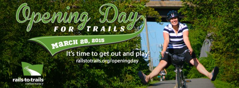
Yes and No - the trail is already open all the way to Roberts Pass in London with a connection to the Prairie Grass Trail. The trail is partly open to the east, it is complete to Galloway Road presently and it will soon extend into the Hilltop and connect to Holton Park on Eureka Ave. "Opening Day for Trails" is a National event organized by the Rails to Trails Conservancy each year since 2013.
The competed Camp Chase Trail will be a 15 mile paved trail connecting London and Columbus. Currently, it is 9.4 miles and the main trail access is at Battelle Darby Creek Metro Park; 8465 Alkire Rd, Galloway, OH 43119, Amenities include Restrooms, Picnic Area, Canoe Access, Overnight Car Parking (w/self registration) Map Locator Coordinates: 39.893482,-83.215803
|
|
| NE Camp Chase Trail (5.6 miles in process) |
Want to get involved and help support the Trail?
-
Use the Camp Chase Trail regularly, pick up litter and report maintenance issues
-
Sign up for the e-newsletter
-
Engage and Share Ideas on MindMixer (see card with instructions)
-
Post photos and tag them #CampChase #OhiotoErie and #RTCOpeningDay
-
Attend a trail friends meeting: Thurs April 30, 6:30 pm at Haydocy, 3895 W. Broad St.
Attend an upcoming greenways Trail Volunteer training (spring dates coming)
|
|
| SW Camp Chase Trail, 9.4 miles complete |
Trail Use Guidance:
-
Always YIELD when the trail crosses a street, often the motor vehicles will NOT have a stop sign
-
On the trail, stay to the RIGHT especially when someone is passing you
-
To pass slower moving trail users, say "Passing" or ring a bell; then pass on their LEFT side
-
For assistance on the Camp Chase Trail call Greenways Rangers 614-230-7191 or Ranger Dispatch at 614-620-1865
-
For help within Battelle Darby Creek Metro Park call Ranger on Duty at 614-370-6254
-
In an emergency always dial 911
-
Oniline Camp Chase Trail Map is found at www.traillink.com
How far do you want travel?
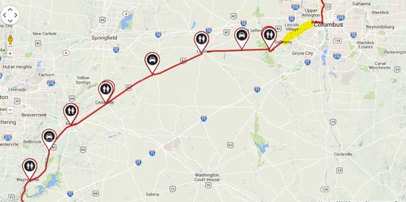
WEST ROUTE: (from the Trailhead)
[11.8 miles from Trailhead to Maple St in London]
3.5 miles to Lilly Chapel (look for the large grain elevator next to the trail, on the left)
1.7 miles from Lilly Chapel to Wilson Road SE where it joins the Roberts Pass Trail
6.6 miles on Roberts Pass to Maple St (where trail ends)
Directions to London Coffee Peddler (open until 1 pm):
[Under a mile from from the Roberts Pass Trailhead]
Turn left onto Maple St
Turn right onto E Center St
Turn right onto S Main St
London Coffee Peddler 127 South Main Street, London, OH 43140 ph: (614) 578-1040
CONTINUE WEST:
If you are up for a longer route - Visit the other Ohio Opening Day celebrations (85 miles roundtrip)
Westbound (distance from Darby Creek trailhead):
13.3 miles to London Prairie Grass Trailhead (Madison County Senior Center)
24 miles to South Charleston
42.5 miles to Xenia
EAST ROUTE:
To reach the east trail, use the Park Connector [1.5 miles to Park Entrance]
Travel South on the Indian Ridge Trail to the parking lot of the Indian Ridge Area
Travel on the road up the steep hill to the entryway of the Indian Ridge area (along Darby Creek Dr.) the eastbound Camp Chase trailhead is located near the park entrance. Bicycles use road, hikers can use the Terrace Trail
EAST TRAIL ROUTE
[3.8 miles from trail at Indian Ridge Park entrance to Norton Road]
2.5 miles to Galloway Road (paved)
1.3 miles from Galloway Rd to Norton Road (crushed gravel)
-Trail End -
-----