|
A Message From the Core Committee
Greetings Volunteers and Friends:
With the new year comes a renewed sense of purpose and motivation. Formidable challenges abound, but there's real empowerment that comes with being part of this community of volunteers, partners, and supporters who are focused on solutions. Whether you're a new
GISCorps volunteer
waiting to join your first mission or a veteran who's served on several, you're part of the solution. If you're a
GIS Service Pledge participant
using your geospatial skills to support a local cause or if you've
requested a GISCorps volunteer
so your nonprofit can leverage the power of GIS, you're part of the solution. And if you're a
GISCorps supporter
who makes it all possible by donating money, services, or software, you are part of the solution too! Each of you has taken action to address our shared challenges and we are all strengthened by your commitment.
2020 is shaping up to be an exciting year of new and continued collaborations with partners seeking to make positive differences all over the globe. URISA's GISCorps Core Committee is currently exploring long-term collaborations with several organizations that are likely to provide new opportunities for meaningful remote and on-site volunteer GIS work related to conservation and disaster response. Stay tuned!
Speaking of collaborations, we're delighted to announce that GISCorps has added a new member to our Core Committee! Drawing on her experience serving on GISCorps missions focused on floods, fires, and hurricanes,
Erin Arkison
will specialize in coordinating disaster response missions. Erin joined the Core Committee in December and hit the ground running: in early January, she co-led our mission responding to the earthquakes in Puerto Rico with perennial partner
NAPSG
. For more on that mission, read on!
With warmest regards and deepest gratitude,
The GISCorps Core Committee and Advisory Board: Shoreh Elhami, Erin Arkison, Dianne Haley, Konrad Hughes, Allen Ibaugh, Carol Kraemer, Wincy Poon, German Whitley, Troy Wirth, and Chris Zumwalt.
P.S. Please email
[email protected]
if you wish to be removed from this list.
|
| Deployment and Partnership News |
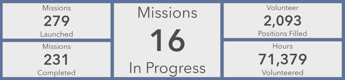
Missions in Progress
Sixteen m
issions are currently underway.
You can always find information about in-progress missions on the
New and Ongoing Projects
page
of the GISCorps website.
|
Completed Missions
A series of powerful earthquakes shook southwestern Puerto Rico the week of January 5, 2020. The
National Alliance for Public Safety GIS Foundation (NAPSG)
requested support from URISA's GISCorps &
CEDR Digital Corps
volunteers to mine social media and news outlets for images of on-the-ground conditions in the affected area and upload them to a Survey123 form. The resulting dataset was displayed in an online
dashboard with embedded apps
, including ESRI's new
Attachment Viewer configurable app
. These applications provided valuable situational awareness to federal, regional and local emergency managers.
Read more about this project here.
2020 Disasters Crowdsourced Photos Dashboard being used to brief FEMA & Government officials (photo posted to Twitter by Acting DHS Secretary Chad Wolf).
 The nonprofit, volunteer-run
Texas Justice Initiative (TJI)
obtains, analyzes, and publishes public data about the Texas criminal justice system that would otherwise be difficult to access. Their user-friendly interface was developed by volunteer data scientists and developers using open-source technologies to facilitate replication by similar organizations in other states. TJI requested an open-source web GIS programmer to develop tools for geocoding incoming data and eventually adding interacting mapping and geographic search functionality to the data portal. Texas-based GISCorps volunteer Jonathan Pascoe, with his education and experience in both open-source web development and the fundamentals of geospatial science, was the perfect candidate for the job. The nonprofit, volunteer-run
Texas Justice Initiative (TJI)
obtains, analyzes, and publishes public data about the Texas criminal justice system that would otherwise be difficult to access. Their user-friendly interface was developed by volunteer data scientists and developers using open-source technologies to facilitate replication by similar organizations in other states. TJI requested an open-source web GIS programmer to develop tools for geocoding incoming data and eventually adding interacting mapping and geographic search functionality to the data portal. Texas-based GISCorps volunteer Jonathan Pascoe, with his education and experience in both open-source web development and the fundamentals of geospatial science, was the perfect candidate for the job.
Read more about this project
here
.
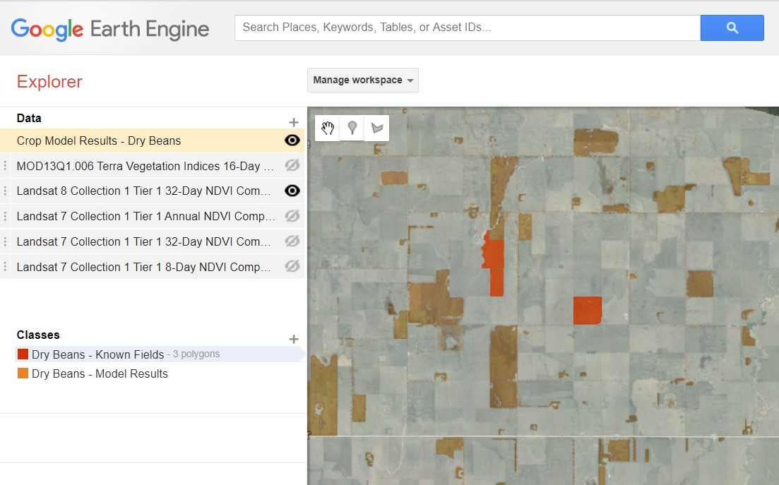
Food Aid Project, Inc.
is a nonprofit organization that works toward improving the efficiency of and access to the bulk food procurement and distribution network. When they needed a GIS specialist to help them using remote sensing and spatial modeling to predict edible bean yields, they contacted GISCorps. Volunteer Jill Stanford was selected for the role, and she proceeded to evaluate imagery sources, digitize bean field locations, and conduct spatial analysis on identified field locations for yield prediction. Using Google Earth Engine, Stanford generated initial crop models with Landsat and MODIS imagery, and was able to use those models to estimate yield at a regional scale.
Read more about this project
here
.
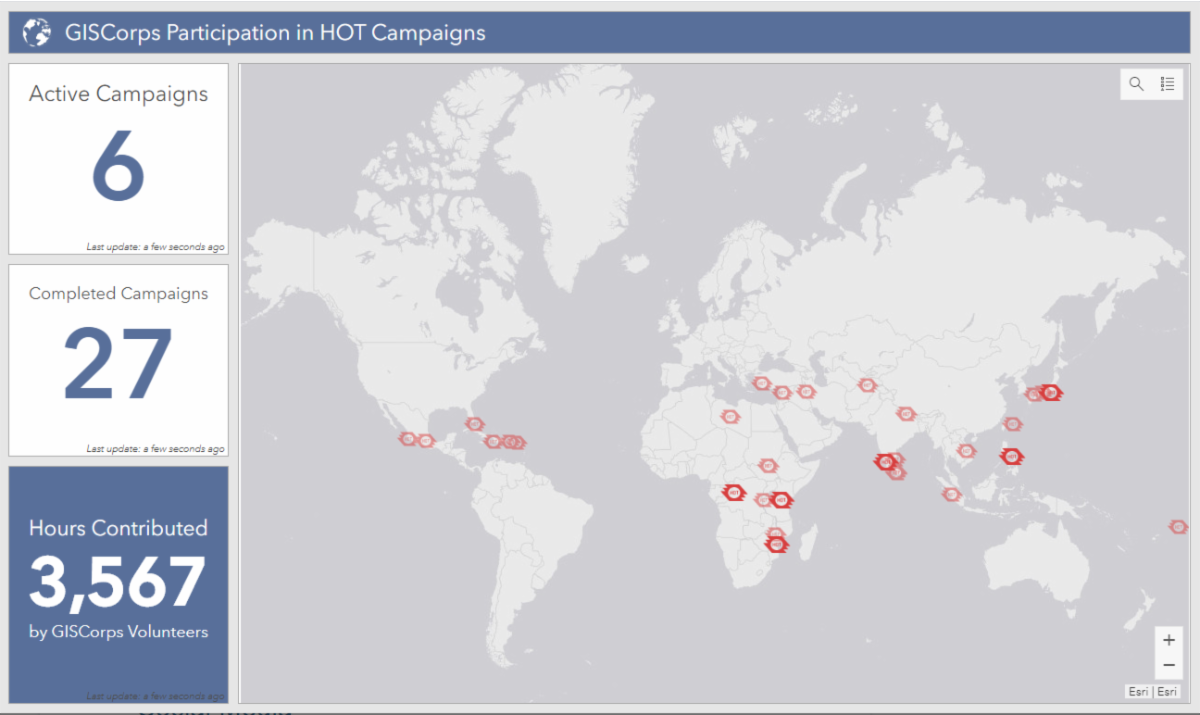
Humanitarian OpenStreetMap Team (HOT) continues to request support from GISCorps volunteers for urgent projects that have unmet demand for highly skilled OpenStreetMap editors. Since 2011, at least 210 GISCorps volunteers have contributed over 3,560 hours mapping and validating 33 HOT campaigns. Efforts are ongoing for the following HOT projects:
Click here for more information about GISCorps's involvement with HOT, as well as information about how to get started mapping with HOT.
If you are already a GISCorps volunteer and a HOTOSM contributor, please remember to add #GISCorps to your changeset comments when you save your edits and don't forget to keep track of the hours you spend mapping. When you're finished, fill out this Google form so we can accurately track and report GISCorps volunteer contributions to HOTOSM projects. You'll also receive documentation of your contribution, which can be used for GISP credit.
|
|
The
GIS Service Pledge (GSP)
is a collaboration between Esri, URISA's GISCorps, and YOU! Invent your own GISCorps mission to support organizations or causes that would benefit from GIS expertise, applications, or analyses.
Esri generously provides one-year ArcGIS personal use licenses that volunteers can use to make a difference in their own communities or across the world.
So far, GISCorps and Esri have approved 47 GIS Service Pledge applications submitted by volunteers from seven different countries. As participants wrap up their projects, we delight in reading their reports and learning how they were able to contribute to organizations they care about. You can read them, too, on this page of our website, which is dedicated to GIS Service Pledge project reports. You can also see where GSP participants are making a difference on this web map.
Here are some recent highlights:
- Samuel Mwenda used his Esri Personal Use license to evaluate the use of constructed wetlands for urban storm water management in Florida's Halifax River watershed.
- D. Scott Stevens renewed his GIS Service Pledge to continue mapping public lands and trails for the Land Trust of North Alabama.
Do you know of a nonprofit organization that could benefit from your GIS expertise? Review the GIS Service Pledge guidelines and apply for the program here. Send any questions specific to the GIS Service Pledge to [email protected]. And if you are a GISCorps volunteer who has identified a worthwhile GIS Service Pledge project idea, but would prefer to work within the supportive structure of a formal GISCorps mission, we'd love to hear about your idea too! In many cases, you can encourage the organization you'd like to help to request GISCorps support, and GISCorps can then launch a new project with you as the volunteer, bypassing the recruitment process.
|
| Conference News & Announcements |
GIS-Pro 2020
URISA's GIS-Pro 2020 conference
will take place in Baltimore, MD, September 27-October 1. The program specifics will be available in late March, which is also when registration will open. S
ubstantial registration discounts are available for full-time students, young professional members (35 or younger) and members of URISA. Conference sessions will highlight topics in the following categories:
- GIS Leadership & Management
- Community Resilience & Sustainability
- Equity & Social Justice Implications of GIS
- GIS Supporting Health & Human Services
- Data Management and Analysis
- Geospatial Technology Innovations
- NextGen 9-1-1
- Federal GIS
- National Spatial Reference System/Datums 2022
- Inspiring the Future of GIS and Education
URISA will again host a Silent Auction to support GISCorps.
|
Name:
Jill Stanford
Organization:
Precision GIS, LLC
Share your experience about the mission:
GISCorps is an incredible program to provide valuable aid with your GIS skills. As a volunteer, I was able to support a Food Aid Project to help develop innovative technology to feed the hungry and was able to utilize the latest beta version of Google Earth Engine for spatial analytics. Looking forward to the next mission!
For more volunteer profiles, visit the Our Volunteers page of our website.
|
| Thank you for your continued support of URISA's GISCorps! |
|
|
2020 URISA Professional
Education Calendar
|
For more information, click here.
|
| Social Media |
|
If you haven't already, please join us on social media:
Facebook page Facebook group Twitter account LinkedIn page LinkedIn group Instagram Slack workspace
If you'd like to help us get the word out, please check out the
resources on
our website
. Also, please double check that the 'giscorps.org' domain is not being sent to your Spam folder.
|
| Our Supporters:
GISCorps is grateful for the generosity of the following corporate sponsors as well as many individual supporters.
To see who else supports URISA's GISCorps and to learn about sponsorship opportunities, please visit our Supporters page.
|
| |
| URISA's GISCorps Core Committee & Advisory Board |
| Erin Arkison Shoreh Elhami Dianne Haley Konrad Hughes Allen Ibaugh Carol Kraemer Wincy Poon German Whitley Troy Wirth Chris Zumwalt GIS/Administrative Assistant: Holly Torpey Contact us: www.giscorps.org Email: [email protected] |
|
|
|