|
A Message From the Core Committee
Greetings Volunteers and Friends:
GISCorps wrapped up 2018 on a somber yet rewarding note as we partnered with Esri and Butte County, California, to consolidate structural damage data following the devastating Camp Fire. This was our first wildfire response mission, and like most disaster response projects, it was a learning experience for everyone involved. As always, we're incorporating what we've learned into our procedures so that we'll become a little bit more effective with each mission we complete.
The Camp Fire mission brought us to a total of 254 GISCorps missions launched by the end of 2018. And just a month and a half into 2019, we're already recruiting for two more projects and have an additional four in the planning stages. With our ongoing support of Humanitarian OpenStreetMap Team projects and the unfortunate likelihood of more disaster response projects on the horizon, we expect to have plenty of opportunities for our 5,600+ volunteers to put their GIS skills to work helping communities around the world. And with the GIS Service Pledge Program now in its second year, enterprising GISCorps volunteers continue to identify organizations and causes within their own communities or areas of interest where they know their GIS expertise can make a difference.
We are thankful for your continued support of URISA's GISCorps and grateful to our volunteers for their remarkable service.
With warmest regards,
GISCorps Core Committee: Shoreh Elhami, Dianne Haley, Allen Ibaugh, Carol Kraemer, Wincy Poon, German Whitley, Troy Wirth, Leslie Zolman, and Chris Zumwalt.
|
| Deployment and Partnership News |
Missions in Progress
At this time, volunteers are actively working on three GISCorps missions, with five more missions in the early planning and recruitment stages.
More details on launched projects are posted on our What We Do web page under New and Ongoing Projects.
|
Featured Projects
Collaboration with Mountain Rescue Association 
URISA's GISCorps is proud to announce the beginning of a collaboration with
Mountain Rescue Association
, a 501(c)(3) nonprofit organization that provides training and education to over 90 search and rescue units in the United States and Canada. Since 2014, MRA has maintained a Mission Data Portal powered by ArcGIS Online where member search and rescue teams enter mission data, which can then be mapped and analyzed to further MRA's objective of saving lives through rescue and mountain safety education. MRA has asked GISCorps to provide volunteers to provide user support, to develop an Operations Dashboard, to improve data integration and management, and to perform spatial analysis. Stay tuned to hear more about these exciting missions in the coming months. And in the meantime, you can learn more about MRA's inspiring work by watching
this video
.
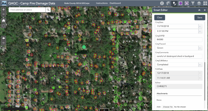
Consolidation of Wildfire Damage Data in Butte County, California
When the Camp Fire devastated most of the town of Paradise and its surrounding communities, the Butte County GIS department had the daunting task of compiling structural damage data statistics so that the County could apply for FEMA assistance. Multiple structural damage surveys had been conducted by the California Department of Forestry and Fire Protection (CAL FIRE) and County inspectors, resulting in several datasets with different attributes and varying degrees of locational accuracy. Butte County partnered with Esri to develop an ArcGIS Online application to facilitate the reconciliation and consolidation of these survey datasets, and 14 GISCorps volunteers stepped up to get the job done. Together with two GISCorps project managers, the volunteers put in more than 350 hours combing through the survey points, using addresses, parcel numbers, photographs, and both satellite and street-level imagery to match and consolidate the points to the extent possible. Read more about this somber collaboration
here
.
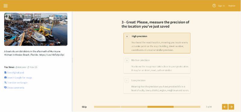
Round Two of Crowd4EMS Application Testing for E2mC Project
Funded by the European Commission, Crowd4EMS is the crowdsourcing component of a suite of open-source applications collectively known as Copernicus Witness.Copernicus Witness was designed to combine social media listening, machine learning, and crowdsourcing to produce an accurate spatial dataset of on-the-ground conditions within the crucial first hours following a natural disaster or humanitarian crisis.
After incorporating the feedback provided by GISCorps volunteers and others who had participated in a simulated crowdsourced response to the 2017 earthquake in Amatrice, Italy,
the E2mC Project team requested GISCorps participation in a second round of application testing. This time, the Crowd4EMS application simulated a crowdsourced response to Hurricane Michael in the southeastern United States. Eleven GISCorps volunteers responded, contributing an additional 30 hours of application testing. Read more about this project here.
HOTOSM Projects
We're pleased to announce that we have added a
Humanitarian OpenStreetMap Team page
to our website! On that page you'll find links to the most current projects for which HOT has requested GISCorps volunteer support, as well as links to HOT resources for volunteers just getting started as HOT editors or validators.
GISCorps volunteers continue to contribute their skills to Humanitarian OpenStreetMap Team projects around the globe. Top priorities continue to be tasks related to Cyclone Gaja and the Ebola outbreak in the Democratic Republic of the Congo. Work on areas affected by flooding in Kerala, India, and southwestern Japan continues as well. Cumulatively at least 41 volunteers have contributed over 310 hours digitizing and validating 11 different projects, and efforts are ongoing.
If you are a GISCorps volunteer and a HOTOSM contributor, please remember to add #GISCorps to your changeset comment when you save your edits and don't forget to keep track of the hours you spend mapping. When you're finished, fill out this Google form so we can accurately track and report GISCorps volunteer contributions to HOTOSM projects. You'll also receive documentation of your contribution, which can be used for GISP credit.
|
|
The GIS Service Pledge (GSP) is a collaboration between Esri, URISA's GISCorps, and YOU! This unique program allows GISCorps volunteers to invent their own GISCorps missions, identifying organizations or causes that would benefit from GIS expertise, applications, or analyses. Esri generously provides one-year ArcGIS personal use licenses that volunteers can use to make a difference in their own communities or across the world.
So far, GISCorps and Esri have approved 34 GIS Service Pledge applications submitted by volunteers from eight different countries. As the first participants have wrapped up their projects, we've had the distinct joy of reading their reports and learning how they were able to contribute to organizations they care about. We're sharing their inspiring stories on a
new page of our website
devoted to their accomplishments. You can also see where GSP participants are making a difference on
this web map
.
Here are some highlights:
- Scott Stevens created kiosk maps for the Land Trust of North Alabama and a wheelchair ramp map for Care Assurance System for the Aging and Homebound of Madison County, Alabama.
- Guy Maurice and Adam McKay prepared data and developed web mapping applications for three World Health Organization (WHO) polio mapathons in Africa.
- Leslie Zolman prepared and managed mapathons for the WHO and the Centers for Disease Control and Prevention in Africa and southwestern Asia.
- Eadie Kaltenbacher developed interactive web maps, collected and integrated data, performed analyses, and created story maps to support numerous public initiatives for the Oregon Environmental Council.
- Diane Ambrose created watershed maps for the Beaver Ponds Environmental Education Center in Colorado.
Do you know of a nonprofit organization that could benefit from your GIS expertise? Review the GIS Service Pledge guidelines and apply for the program here.
Alternatively, if you are a GISCorps volunteer who has identified a worthwhile GIS Service Pledge project idea, but would prefer to work within the supportive structure of a formal GISCorps mission, we'd love to hear about your idea too! In many cases, you can encourage the organization you'd like to help to request GISCorps support, and GISCorps can then launch a new project with you as the volunteer, bypassing the recruitment process. Please send any questions specific to the GIS Service Pledge to [email protected].
|
| Conference News & Announcements |
GIS-Pro 2019
URISA's GIS-Pro 2019 conference
will take place in New Orleans, Louisiana, September 28-October 2.
Registration information is available
here
, and substantial discounts are available for full-time students, young professional members (35 or younger) and members of URISA.
Presentation proposals in these topical themes are being reviewed for the program:
- GIS Leadership & Management
- Community Resiliency and Sustainability
- Social Justice and Equity Implications of GIS
- GIS Supporting Health and Human Services
- Data Management and Analysis
- Geospatial Technology Innovations
- Inspiring the Future of GIS and Education
The conference will again host a Silent Auction to raise funds to support GISCorps! Make plans to join us in New Orleans!
|
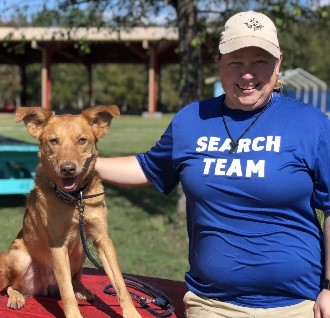
Name:
Erin Arkison
Organization:
Alpha Search and Recovery (Volunteer),
NAPSG (Volunteer), and EOG Resources (Senior GIS Analyst)
Share your experience about the missions:
I stumbled upon GISCorps in the week leading up to Hurricane Florence when we joined forces with NAPSG to help manage a Crowdsource Story Map. After working closely with other members of GISCorps during Florence and then a few weeks later with Hurricane Michael, I knew that I wanted to become a member myself. The Butte County Data Consolidation project was my first official GISCorps effort. I was a little apprehensive at first because I was working a tad bit out of my comfort zone. But I soon realized
how this project was going to help not only the citizens of Butte County but also the personnel working to reestablish normal working order. It's hard to put into words what helping with this project has done for me personally and I hope to use the things I learned to benefit GISCorps going forward.
Anything else to share:
Volunteering is what fuels me and as a member of my local search and rescue team, I am able to help in and around Houston when the need arises. But by volunteering with GISCorps I am able to help a much broader community. I think that in the moment you may not realize that something like geolocating photos or consolidating thousands of data points makes that much of an impact. But to the end users it means everything. I urge anyone thinking about volunteering for a project to just do it! You won't regret it!
Name:
Konrad Hughes
Organization:
Missouri Office of Administration
Share your experience about the mission:
It felt good to be a part of a team trying to help following a huge disaster and make a real impact, and when Butte County gave us more data after we'd finished the first batch, it made me realize that our work was making a huge difference and that the community was relying on our work.
Anything else to share:
It was awesome to use what I do to directly help people get what they need after such a huge disaster. I would really like to work again on any missions that come up.
|
| Thank you for your continued support of URISA's GISCorps! |
|
|
| URISA's GISCorps Core Committee |
| Shoreh Elhami Dianne Haley Allen Ibaugh Carol Kraemer Wincy Poon German Whitley Troy Wirth Leslie Zolman Chris Zumwalt GIS/Administrative Assistant: Holly Torpey Contact us: www.giscorps.org Email: [email protected] |
|
| Social Media |
|
If you haven't already, please join us on social media:
Facebook page Facebook group Twitter account LinkedIn page LinkedIn group Slack workspace
If you'd like to help us get the word out, please check out the
resources on
our website
. Also, please double check that the 'giscorps.org' domain is not being sent to your Spam folder.
|
URISA Professional
Education Calendar
|
|
2019 GIS/CAMA Technologies Conference
CalGIS 2019
GIS-Pro 2019
2019 Caribbean GIS Conference
For more information, click here.
|
|
|
Support GISCorps with a tax-deductible donation in 2019. Your support is greatly appreciated!
If you would like to donate specifically to support the #Map4PR project, please do so
here
.
|
|
|