|
This proposed design is the very same design that the City declared to be NOT RECOMMENDED Due to Potential Boulevard Impacts in their June 6, 2022, Public Information Session. The voices sounding this alarm within the City have now been silenced.
- The claim that an off-road trail will be safer is false.
- Industry standards warn that building sidewalk level trails in a setting like Summit Avenue, with many conflict points, makes it more dangerous for everyone.
- Summit Avenue averages conflict points every 40 feet
(driveway, carriage walk, cross-street).
- Cyclists are at greater risk of being struck on off-road trails
with a high number of conflict points.
The bike activists are trying to deceive the public
Building the off-road bike trail is not “swapping the bike lanes and parking”, but forces:
- Moving all the curbs
- Excavating and moving the storm sewers beneath the curbs, many by over 9 feet
- Rebuilding and extending 150 driveways
- Rebuilding and extending 300+ carriage walks
- Regrading the boulevards for proper drainage
All of this construction activity is only due to building the trail, not street reconstruction, and will destroy the root zones of most of the trees on the boulevard.
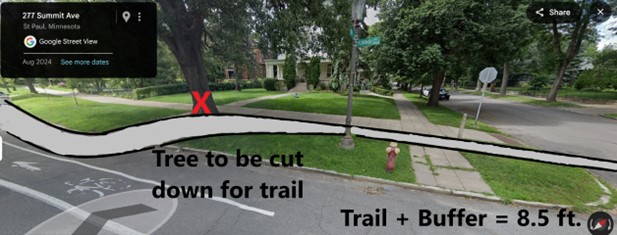
At the 46 street intersections, ALL corner trees will be sacrificed (see following image).
Trees will be lost. Approximately 950 trees, almost two-thirds of Summit’s iconic canopy, will be lost. These trees will either be removed immediately or will be unlikely to recover from the construction impact and die within 5 years. This is not laser surgery.
All of Summit Avenue does not need to be completely reconstructed
- Contrary to the City’s claims, the City’s own data establishes that only 17% of the segments currently scheduled for work meet the City’s criteria for being last reconstructed over 65 years ago.
- The older sections of Summit are not even on the construction schedule.
- The only reasonable conclusion is that the City has escalated reconstruction of these segments to justify building an unneeded and unwanted bike trail for political reasons.
St. Paul cannot afford to spend millions to subsidize a small number of bike activists
- The City’s cost estimate for the bike trail on Summit is $2.5M+/mile for a total of over $12M for 5 miles. The MN State Demographic Center states that in 2023 only 0.6% of St. Paul’s population commuted to work, year-round, on bicycles. Rounding to 1% to include recreational cyclists, there are likely only around 3,000- regular cyclists in St. Paul, of which only some portion will use Summit. A conservative estimate of cost for this trail is around $4,000 per user.
- Bowing to a very small fraction of the community, the Mayor wants to destroy the irreplaceable tree canopy and historic character of Summit Avenue and assess all Summit property owners for the ‘improvements’. Based on the 2026 Proposed Capital Improvement Budget, for the first proposed 1.0-mile segment each property will be assessed an average of $30,000.
|