March 5, 6:00 pm:
March 9, 4:00 pm:
March 10, 5:30 pm:
Grafton Town Garage
March 10, 6:00 pm:
Grafton Town Garage
March 31, 6:00 pm:
Location TBD
**All Committee meetings take place in the WRC Conference Room unless otherwise noted.
**All meetings are subject to change, please check the website for updates.
|
UPCOMING GRANT OPPORTUNITIES
Vermont Arts Council - NEW!
Special funding opportunity for communities poised to integrate works of public art into upcoming infrastructure projects.
DEADLINE: March 10, 2020
New England Grass Roots Environmental Fund
DEADLINE: March 15, 2020
USDA Rural Development
Community Facility Loans & Grants
Communities with populations of 20,000 or less
DEADLINE: Ongoing (contact USDA office)
Communities with populations of 10,000 or less
DEADLINE: Ongoing (contact USDA office)
Vermont Agency of Commerce and Community Development
DEADLINE: Rolling
Projects must be located in designated downtown's.
DEADLINE: March 9, 2020
Additional Clean Water Initiative Funding Available
DTF projects may apply for up to $100,000 of "add on" clean water funding for eligible storm water implementation projects.
Vermont Natural Resources Council
DEADLINE: Rolling
DEADLINE: Rolling
Windham Regional Commission
DEADLINE: Rolling
DEADLINE: Rolling
For additional information about
grant possibilities for your projects please contact Susan Westa.
|
|
Windham Region Broadband Surveys to be Released
Broadband surveys will be released on February 14, 2020 and will be available online at WRC's new
Broadband webpage.
Please help us spread the word in your community about the survey and the importance of participating. This survey, along with other available data, will form the basis of the Broadband Feasibility Study and Business Plan for the Windham Region.
The original survey training workshop had to be rescheduled due to inclement weather. The snow date for the survey training was Thursday, February 13
th
6:00-8:00PM at the Newbrook Fire Department in Newfane. The training provided communities with the tools and information they need to successfully implement the survey. Strategies for distributing the survey include posting flyers at community gathering spaces, handing out cards or flyers at Town Meeting, the town dump and/or the local library - any places folks gather in town. Flyers and cards can be downloaded from WRC's website.
Please also consider writing articles that can be included in town newsletters or other local publications. A project summary sheet is available on the website for use in local publications. Feel free to tailor the summary sheet and add information that is specific to your community. Refer to the FAQ (frequently asked questions) section of the webpage to address some of the many questions folks are asking.
While we're hoping that most people will be able to access the survey online, each community should have paper surveys available as needed. If your town hall/office isn't open full time, consider leaving a box of paper surveys just outside the door with a sign directing people to help themselves.
WRC would like to thank our communities for doing all they can to get the word out about the survey.
The deadline for collecting all surveys is March 17, 2020. If you have any questions or need assistance, please contact
Susan Westa.
|
|
WRC Annual Town Officials Update
Town Meeting Day is quickly approaching!
Please note: WRC has emailed blank Town Officials & Commissioner Appointment Forms to all towns. Please return completed forms with updated and accurate information to
[email protected].
We ask towns to please appoint commissioners by April 1st to avoid any lapses in representation on the Commission, and to have appointments made before our new commissioner orientation session.
Please help us keep our records up to date by sending in your forms as soon as the information is available. Forms from previous years are available for your town upon request.
Please contact
WRC with any questions.
|
Windham Connectivity Collaborative
After the passage of Vermont Act 171, an amendment to VT Planning Statutes to address the protection of forest block and habitat connectors, several communities in the region started to look at ways to address identifying and protecting wildlife corridors. Since wildlife do not observe town boundaries, several towns joined together to address habitat connectivity on a larger scale.
From those early meetings, the multi-town collaborative decided to focus on addressing a North/South corridor that would stretch from the Massachusetts border, head northeast and link to the Green Mountains. The towns in this linkage corridor include
Guilford, Halifax, Marlboro, Newfane, Wardsboro, Dover, Townshend, Stratton and Jamaica.
Windham Regional Commission assisted the group in securing grant funding from the High Meadows Fund. This funding is to
support
a comprehensive conservation planning effort working in partnership with towns, landowners, citizens and grassroots groups to organize, inventory and connect wildlife tracking within high-priority habitat, conserve critical wildlife corridors, and develop regional policies rooted in the local landscape.
With the assistance of the High Meadows Fund, Windham Regional is also helping address wildlife corridors on a regional scale. There are many important linkages throughout our region, from the scale of an individual road crossing level to a multi-town forested landscape level. Windham Regional will be providing educational opportunities and a chance for towns, groups, and individuals who are working on habitat connectivity to join together to address a connected landscape on a regional level.
|
Executive Director
Office Manager
Transportation Planning Tech
Senior Planner
Senior Planner
|
|
 |
|
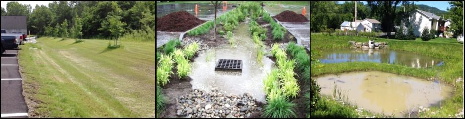
Stormwater Master Plan Winter 2020
When it rains or the snow melts, all of the water that hits the ground has to go somewhere. Most often, in natural areas, water is absorbed into the ground to recharge groundwater, is captured in wetlands, and/or provides water to streams and plants. In areas with more human development, water often doesn't have a chance to penetrate deep into the soil and runs across the surface of the land, down roadways, into ditches or storm drains, and eventually into waterways. This unfiltered surface runoff is stormwater.
|
|
|
Images Courtesy of VT DEC
|
Stormwater occurs anywhere where we have human development on the landscape. It is not just an urban problem; our rural communities also feel the impacts of stormwater. Stormwater can cause:
- flooding,
- damage to public and private property,
- eroded roadways, hill sides, and streambanks,
- sediment clogged waterways,
- excess nutrients flushed into our waterbodies, and
- chemical contaminants flowing unfiltered into rivers and streams.
A stormwater master plan has been shown to be the most cost effective approach to addressing stormwater and the damage it causes to our waterways.
The goal of stormwater master plans is to maintain and protect the quality of rivers, ponds and streams so that they are healthy for aquatic life, human enjoyment, and community uses. A stormwater master plan is typically prepared by a consultant working with the municipality. The master plan may include:
- a review of pre-existing data,
- an on-the-ground assessment of stormwater runoff and erosion problem areas,
- identification of potential projects to address noted problems, and
- the development of conceptual designs for several identified projects.
The Vermont Department of Environmental Conservation is likely to be offering a competitive Ecosystem Restoration Program grant round to help communities develop Stormwater Master Plans (SWMP's). It is anticipated that the next round of grants will be announced in the Spring or Summer of 2020.
Windham Regional Commission is interested in working with a few communities in the region to explore applying for funding and getting cost estimates for the development of a Stormwater Master Plan. If you have any questions or would like to explore working with Windham Regional Commission, please contact Natural Resources Planner
Margo Ghia at (802)-257-4547, ext. 116.
|
|
2020 Census Data Will Feature New "Places" in the Windham Region
 |
|
|
The Census Bureau says
"South Londonderry, you exist!"
|
Villages such as Grafton or Whitingham or South Londonderry have existed since at least the 1800's, and neighborhoods like Stratton Mountain or Chimney Hill have been around for decades. But starting in 2020, the U.S. Census Bureau will begin officially begin recognizing these locations as actual places. That's because last year Windham Regional Commission provided suggestions to the Census Bureau to create a Census Designated Place, or CDP, for 13 unincorporated villages and neighborhoods in the region.
A CDP is what the Census Bureau refers to as a "statistical area," a geographic unit that isn't a political entity like a county, town, or incorporated village (statistical areas also include census tracts and block groups). A CDP allows people to get census data not just for an entire town, but for a specific area in that town-in our case for the many unincorporated villages that dot our region. For example, the median age for all residents in the Town of Putney in 2010 is 39, but for the village area, this statistic is quite different. Because a Putney CDP, whose boundary generally coincides with the unincorporated village of Putney, was created in 2010, we know the median age here is much older: 50 years.
CDPs in the Windham Region include the following unincorporated villages and neighborhoods (an asterisk denotes a new CDP as of the 2020 Census):
- Algiers *
- Brattleboro
- Chimney Hill *
- Grafton *
- Harmonyville *
- Jamaica *
- Londonderry *
- North Westminster (was incorporated, now a CDP)
- Putney
- Readsboro
- South Londonderry *
- Stratton Mountain *
- Townshend *
- Wardsboro *
- West Brattleboro
- West Dummerston *
- Weston *
- Whitingham *
- Wilmington
Data for incorporated villages are already available. Those villages include:
- Bellows Falls
- Jacksonville
- Newfane
- Saxtons River
- Westminster
|
Emerald Ash Borer
Now is a Great Time for Communities to Begin Planning Efforts
Emerald Ash Borer (EAB), a fast moving invasive pest that is estimated to kill off large portions of our native Ash trees, was the topic of multiple presentations in the region in January. For municipalities, EAB becomes a concern as Ash trees along municipal rights of way and in public spaces become hazardous as the brittle dead and dying trees threaten people and property.
|
|
|
|
Joanne Garton of the VT Urban & Community Forestry Program presents at the EAB Preparedness and Management Workshop in late January.
|
|
If your community hasn't started planning for EAB yet, it is not too late. Now, before the infestation becomes widespread in our region, is a great time to begin identifying and building a management plan. Communities can begin by putting together a team to assess the problem and develop a plan. Representatives from selectboards, town conservation commissions, town tree wardens, town road crews, emergency planning committees and interested general public may be willing to serve on an EAB organizing committee. Once a team has been formed, a typical process involves discussing plans with the Selectboard and collecting resources and preliminary information. The team is now ready to conduct an inventory along roads and near infrastructure. Once you know where Ash trees exist, you are in a better position to decide how your community wants to move forward.
After an inventory has been completed, the next steps are to evaluate your community's tree policies and decide on your community's risk tolerance for removals. Some communities want to take a very preemptive approach to removal (let's take down all the Ash trees now) all the way to a reactive approach (let's wait until we see how many trees die and then deal with those). Wherever your community is on the scale, the conversations are important to have. It is also possible to save specimen trees, such as a mature ash tree in a village green, using an insecticide, but this must be applied and maintained for the life of the tree.
With the likely height of Ash tree die-off another ten years out, by starting the planning process now, your community will be ready to address these hazardous trees when the time comes. To help your community get started (or help it move to the next planning stage), visit the Emerald Ash Borer Community Response page at the Vermont Urban & Community Forestry Program. They have a wide variety of planning tools to help municipalities develop an EAB management plan. Their resource page can be found
here.
|
Updating the Windham Regional Plan
The Windham Regional Plan won't expire November 4, 2022, but at its January meeting the Full Commission agreed to pursue a minor plan update in order to create the time and space for a major update that will follow. The Commission intended to get the plan update underway beginning January, 2019, but major staff turnover and related capacity issues required the process to be postponed.
Major Versus Minor Update
The Windham Regional Plan, like state statute and most town plans, calls for development to be focused in and around compact settlements. While the regional plan has served the region well, the Commission has recognized the need to review the plan to answer the question, as a matter of current regional plan policy, when growth comes, where will it go? This question has been prompted by the potential for exurban growth up the I-91 and Route 2 corridors, as well as the prospect of climate change-driven sea level rise forcing coastal New England communities to retreat inland. We are also pondering the prospect of the arrival of both voluntary and involuntary climate refugees.
This leads to some fundamental questions that will take considerable time and effort to engage with the region to answer.
- Where should compact settlement be directed as a matter of policy? This could include the development of planning models for each of the region's compact settlements and contemplation as to whether or not new centers are desirable or needed.
- What is necessary to achieve compact settlement in terms of both policy and implementation strategies?
- What policy and strategies are necessary to make compact settlements climate resilient, with flooding and fluvial erosion as principal concerns given the proximity of many of our communities to rivers and streams?
- What policies and strategies are necessary to prevent forest and habitat fragmentation and to maintain and improve habitat connectivity?
To create the time and space necessary to pursue these larger policy questions through a meaningful and productive public engagement process, the Commission has agreed to pursue a minor update to ostensibly reset the clock on regional plan expiration. This minor update would inform the major update, which would officially commence immediately upon the adoption of the minor update.
Proposed Schedule for 2020-2021
The Commission will pursue the following schedule to accomplish the minor plan update during 2020 and into 2021.
- February-April, 2020
- WRC Committees: Revisit their plan update recommendations and prioritize which are most necessary in the immediate term to improve standing in Act 250 and Section 248 proceedings. Transportation Committee focuses on needed immediate-term updates to the Transportation Plan.
- WRC Staff: Identify what near term improvements can be made to existing data, maps, and other technical aspects of the plan and whether or not these improvements have implications for plan policies. Staff will also develop a recommendation as to how the Windham Regional Energy Plan and Windham Regional Transportation Plan can be better integrated into this update (i.e., as chapters, as appendices, etc.)
- Public Meeting: Held in late February or early March to announce and solicit comment on the commencement of this plan update, including its overall purpose, intent and strategy, and that its goal is to set the stage for a major regional plan update.
-
May-September, 2020
- Public Meeting: Held in mid-May to explain what specific changes to the plan are being proposed and to solicit public comment on those proposed changes.
- Staff: Update maps, data, and plan language, and integrate energy plan, transportation plan, and new regional broadband plan into regional plan.
- Committees: Review updated drafts.
-
October, 2020
- Draft plan is sent to statutory parties for general and specific comments.
-
November-December, 2020
- Two statutorily required hearings are held.
-
January, 2021
- Regional plan is adopted at January Full Commission meeting.
- Plan takes effect 35 days after adoption unless a majority of municipalities veto the plan.
-
March, 2021
- Major plan update continues/ commences.
We'll be reaching out to towns, a broad array of regional stakeholders, the public, and state agencies to explain this process and our related goals. If you have any questions or concerns please contact Executive Director Chris Campany at
[email protected].
|
|
|