NOMEC Newsletter - Summer 2023 | |
This new biannual newsletter from the National Ocean Mapping, Exploration, Characterization (NOMEC) Council is your source for all things related to mapping, exploring, and characterizing the waters within the United States. We will share updates on the NOMEC Strategy goals, advancing science, building ocean-related industries that strengthen the Blue Economy, and progress on mapping, exploring, and characterizing waters within the U.S. Exclusive Economic Zone (EEZ). | |
|
Letter from the NOMEC Council Co-chairs
By RDML Benjamin Evans, Rob Thieler, and Jeremy Weirich
On behalf of the NOMEC Council Co-chairs, hello and welcome to our inaugural newsletter! In 1983, the United States proclaimed its Exclusive Economic Zone, consistent with international law, to extend U.S. interests in exploring, exploiting, conserving, and managing natural resources in the water column, seabed, and subsoil up to 200 nautical miles from U.S. territorial waters. Continuous technological advances have enabled better access to this hidden treasure below our waters. The White House Ocean Science and Technology Subcommittee recognized a need for better data coordination within the U.S. EEZ and released the NOMEC Strategy in 2020. The NOMEC Strategy and Implementation Plan describe the goals and steps to secure a prosperous future for us and our aquatic resources. The NOMEC Strategy is guided by the NOMEC Council, a multi-agency group supported by the Interagency Working Groups on Ocean and Coastal Mapping and Ocean Exploration and Characterization. Since forming, the NOMEC Council has overseen campaigns, engaged with diverse stakeholders, and shared efforts and initiatives related to mapping, exploration, and characterization; check out the NOMEC Fact Sheet and our 2022 highlights. Additionally, progress has been made in mapping the seafloor of our U.S. EEZ, and it is now half mapped! For more information, please visit our website, and if you would like to be involved or have any questions, contact us at nomec.execsec@noaa.gov.
| |
|
Public Engagement: Where to Find Us Next
By Gretchen Spencer
NOMEC is looking at a busy year ahead for public engagement opportunities within the mapping, exploring, and characterizing community! NOMEC and the National Oceanographic Partnership Program (NOPP) are planning a joint town hall at the MTS Oceans 2023 conference (Biloxi, MS, September 25-28, 2023). The focus will be engagement with partners to solicit new ways to apply technological innovation to advance the mapping, exploration, and characterization of the U.S. EEZ. Additionally, NOMEC representatives will give a talk at Lakebed 2030 (Traverse City, MI, September 19 - 21, 2023) and are co-chairing two sessions and a Town Hall at the Ocean Sciences Meeting (New Orleans, LA, February 18 - 23, 2024). They will share progress on establishing data and protocol standards, identifying strategic priorities, sharing data, and supporting innovation of new technologies while engaging with the public. These sessions will have a series of included remarks by NOMEC federal government leads and stakeholders, followed by moderated discussions with audience comments and Q&A. We invite all interested scientists, policymakers, students, and industry representatives to join these sessions and provide perspectives on collaboration to accelerate progress toward meeting the NOMEC Strategy goals. If you know of other engagement opportunities where NOMEC could make a splash, please reach out to us at nomec.execsec@noaa.gov.
Schedule of Upcoming Events
- NOMEC talk @ Lakebed 2030, September 20, 2023, 10:00am ET
- NOPP/NOMEC Town Hall @ MTS Oceans, September 26, 2023, 3:30pm CT
- NOMEC related sessions at AGU Ocean Sciences 2024, New Orleans, LA
* Sharing Best Practices, Data Standards for Ocean Mapping, Exploration, and Characterization - Abstracts Due September 13, 2023
* Advancing Ocean Exploration and Observing Through Large-Scale Collaborations and Technological Advances - Abstracts Due September 13, 2023
* NOMEC Town hall, more information coming in November, 2023
| |
|
News from the Hill: The FY23 National Defense Authorization Act (NDAA) codifies the NOMEC Council
By Chrissy Hayes
The Council is pleased that the FY23 NDAA included additional codification of the NOMEC Council and subsidiary bodies through the National Ocean Exploration Act. NOMEC was established through a Presidential Memorandum, and in just a few short years is now mandated by law. This congressional support greatly benefits the Council as it continues to coordinate national activities to better understand the U.S. EEZ. Congress recognizes the value of the work we do here in NOMEC. In addition to outlining the structure and function of NOMEC and the Interagency Working Groups (IWGs), we are now required to produce several products. The NOMEC Council is required to submit a report to Congress later this year, to share progress on engagement, data management, and partnership opportunities. Much of this work is already underway and included in the NOMEC Implementation Plan.
| |
|
Ocean Climate Action Plan Introduction: Biden Administration releases U.S. Ocean Climate Action Plan
By Wendy Fink and Amanda Netburn
On March 21, 2023, President Biden announced the first whole-of-government Ocean Climate Action Plan (OCAP) to advance climate solutions, promote environmental justice, and ensure sustainable coastal communities and a healthy ocean economy. The OCAP directs near-term specific ocean climate actions to meet three primary goals:
- Create a carbon-neutral future by supporting further transitions to clean energy and reducing and removing carbon;
- Accelerate nature-based solutions to protect and support natural coastal and ocean systems that store greenhouse gasses, reduce the climate threat, and protect communities and ecosystems against unavoidable changes; and
- Enhance community resilience by developing ocean-based solutions that help communities adapt and thrive in a changing climate.
Undertaking the actions described in the OCAP provides other benefits, from new, well-paying, and sustainable jobs, a diverse workforce, and equitable access to the ocean and coasts, to more resilient global food production and future ocean discovery and innovation. The OCAP was developed by the Ocean Policy Committee’s Subcommittee on Ocean Resource Management’s OCAP workgroup. NOMEC will assist in delivering science and technology to inform ocean-climate actions and engage the broader community. More information is available here.
| |
|
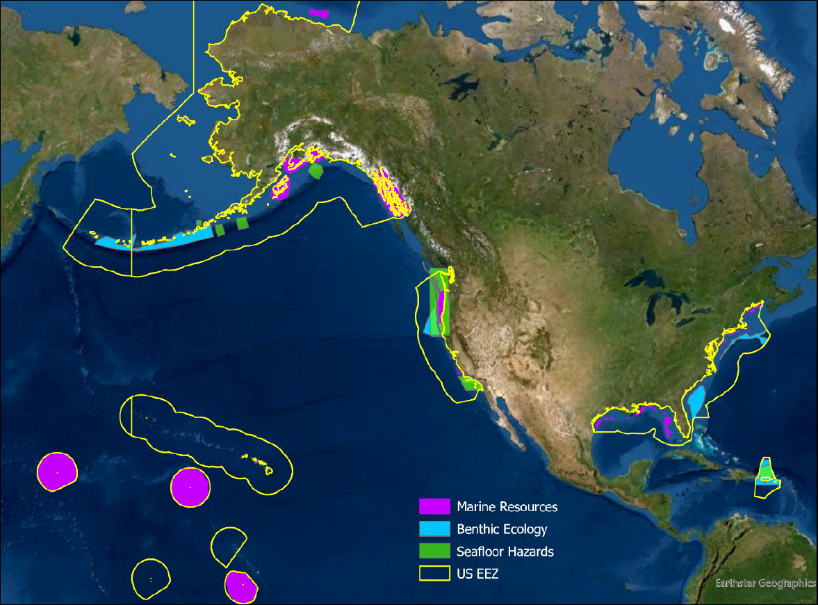
Ocean Exploration and Characterization Priorities: Report Released
By Amanda Demopoulos and Mark Mueller
| |
|
Geographic priority areas provided by the three subgroups that submitted specific polygons.
Understanding the ocean is vital to securing a prosperous future, yet the ocean remains the greatest unknown habitat. As of January 2023, only half of the seafloor within the U.S. EEZ is minimally mapped, and only a fraction is adequately explored or characterized. In 2022, the Interagency Working Group on Ocean Exploration and Characterization, under direction from the NOMEC Council and other White House interagency committees, led the development of an ocean exploration and characterization Strategic Priorities report. Ninety-two subject matter experts from 14 Federal agencies collaborated to:
-
establish priorities across five thematic areas: benthic ecology, seafloor hazards, water column, cultural heritage, and marine resources; and
-
identify and summarize the top geographic priority areas: Aleutian Arc, U.S. Caribbean, California coast and Pacific Islands.
In coordination with the White House, additional emerging topics were identified:
- climate change, biodiversity, and environmental justice.
Public comments solicited via listening sessions and FRNs, reflect these topics and other areas of interest. Common data needs include targeted seafloor bathymetry and backscatter, water column imagery, and physical sampling.
Along with the IWG-OCM’s ongoing federal spatial priorities study and NOMEC Council coordination, the United States is working hard to identify and address the many mapping, exploration, and characterization priorities throughout our ocean.
| |
|
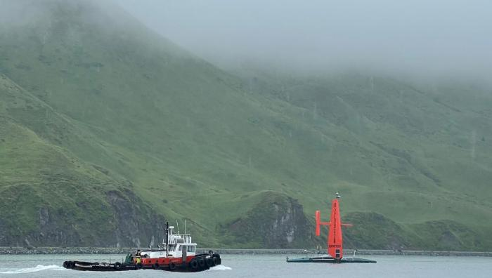
Regional News: Unexplored Waters of Alaska and California Mapped During Uncrewed Expedition
By Mitchell Hebner and Mark Mueller
| |
|
During its 2022 mission, the Saildrone Surveyor made two pit stops in Dutch Harbor, Alaska. Image courtesy Saildrone Inc.
Half of the U.S. EEZ remains unmapped, with Alaska’s waters being the second least mapped area. The White House’s 2022 Strategic Priorities for Ocean Exploration and Characterization report identified the Aleutian Islands as the single highest interagency geographic priority region with mission needs shared by the National Oceanic and Atmospheric Administration (NOAA), the Bureau of Ocean Energy Management (BOEM), and the United States Geological Survey (USGS). These agencies worked together with the Ocean Exploration Cooperative Institute to send the new 72 foot Saildrone Surveyor uncrewed surface vessel on an expedition to Alaska in August 2022 to help shine some light (or more precisely, sound!) on top priority areas such as the Islands of Four Mountains. Despite ferocious 35-knot winds and a close call from Typhoon Merbok, Surveyor successfully mapped 6,276 square nautical miles of seafloor. On the second leg of its mission, Surveyor mapped another 11,475 square nautical miles off the coast of California for NOAA. The mission also collected sea surface oceanographic data from multiple instruments, including a successful operational deployment of the Monterey Bay Aquarium Research Institute’s eDNA Environmental Sample Processor. The collected data will be made publicly available via NOAA’s National Centers for Environmental Information (NCEI) and increase the mapped portions of U.S. waters off Alaska and the West Coast.
| |
|
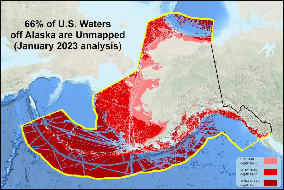
Regional News: Did You Know that 66% of Alaskan Seafloor is Unmapped?
By Meredith Westington
| |
|
A map of unmapped waters in the AK EEZ.
Seascape Alaska was formed in April 2021 to support the NOMEC and Alaska Coastal Mapping strategies. Its focus is primarily on filling bathymetry data gaps, but includes other interests. To track progress, data sharing with NOAA NCEI is a key aspect of the campaign. In 2022, the Alaska region gained 32,500 square nautical miles of new bathymetric data coverage–mainly in the Arctic. This gain marks the single largest annual increase to date. A large portion of this increase is due to the efforts of the Data Management Technical Team to locate pre-existing multibeam data and share it with NCEI. The Alaska Power and Telephone Company donated 8TB of data to this effort. Data from National Ocean Service hydrographic operations, crowdsourced bathymetry, and single-beam bathymetry pipelines are also included. For 2023, we are looking forward to our first Seascape Alaska branded mapping projects, including several mapping expeditions on NOAA Ship Okeanos Explorer and a multi-year project funded by USGS on NOAA Ship Fairweather south of Kodiak. In addition, hydrographic data collection operations from the Office of Coast Survey and its contracting partners using uncrewed systems will be significant this year. Would you like to contribute? Contact Meredith.Westington@noaa.gov.
| |
|
Regional News: Pacific Northwest Expanding Pacific Research and Exploration of Submerged Systems (EXPRESS)
By Nancy Prouty and Jane Rudebusch
| |
|
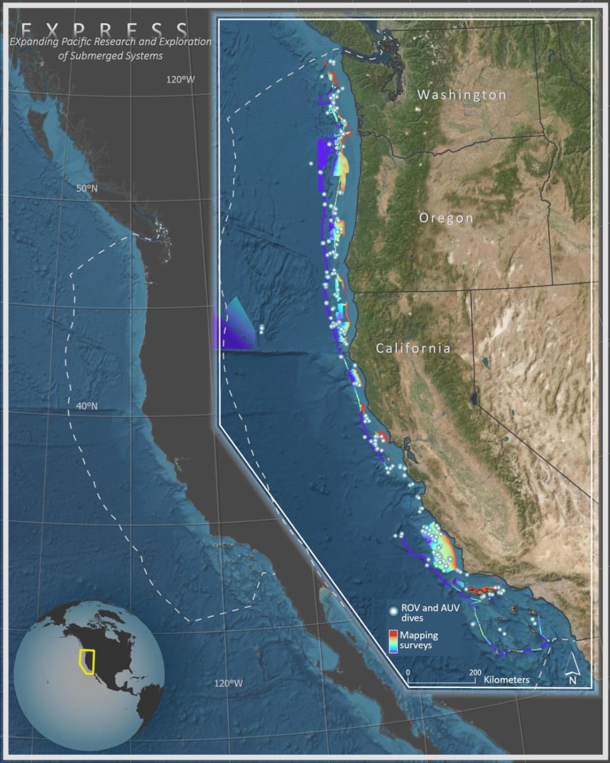
A map showing the operating area for EXPRESS. EXPRESS works in federal waters of the U.S. West Coast offshore Washington, Oregon, and California extending out 200 nautical miles to the boundary of the exclusive economic zone (white dashed line). The inset summarizes bathymetric mapping (color shaded regions) and dives with remotely operated and autonomous underwater vehicles (gray spheres) that EXPRESS has completed since 2017. Map Credit to Jane Rudebusch, USGS
The EXPRESS partnership is a team of federal and non-federal partners (USGS, NOAA, BOEM, Monterey Bay Aquarium Research Institute) working together to map, explore, and characterize U.S. waters of the Pacific Outer Continental Shelf within the EEZ. We are addressing science and management needs focusing on marine geohazards, deep-sea ecosystems, and resources. In 575+ days at sea, we have mapped over 11,954 square nautical miles of the seafloor and collected biological samples for trophic, genetic, and microbial analyses. Our recent efforts have collected 8,592 square nautical miles of mapping data, including 8,585 square nautical miles on NOAA Ship Okeanos Explorer revealed two previously unexplored seamounts, and 737 square nautical miles on NOAA Ship Fairweather (OPR-M328-FA-2 EXPRESS) in support of marine spatial planning for offshore renewable energy, ecosystem and hazards assessments off the coast of Oregon. Our first expedition in 2023, EX2301, successfully completed 15 days of mapping and biological sampling in unexplored regions of the Cascadia Margin. EXPRESS contributes to progress on the 2020 NOMEC Strategy by filling in critical gaps in modern high-resolution multibeam bathymetry, backscatter, and water column data. Visit the EXPRESS Data Viewer web application to explore and access our public data collections.
| |
|
Summary from the NOMEC Team
By Mitchell Hebner, Thalia Eigen, Amber Butler, Gretchen Spencer, Chrissy Hayes, and Amanda Netburn
Thank you for joining us for the premiere issue of the biannual NOMEC Newsletter! Please feel free to forward this issue to other interested stakeholders, colleagues, and academics. If you have been forwarded this email and would like to subscribe to this newsletter, you can email a subscription request to nomec.execsec@noaa.gov. If you do not want to receive future newsletters, you can unsubscribe below or email an unsubscribe request to nomec.execsec@noaa.gov.
| | | | |