|
What the HDR Groundwater Study means for the Wimberley Valley
This analysis is based on a study conducted by the engineering
and environmental consulting firm HDR.
| | |
Engineers are now mapping Hays County's water future...again. In a public forum at the Wimberley Community Center, over 50 people gathered to meet the engineers leading the study and to give their input on the study's scope and importance.
Hays County hired engineering firm HDR earlier this year to build on a history of collaboration on water studies. HDR’s 1989 Hays County Regional Water and Wastewater Study and its 2011 Water and Wastewater Facilities Plan, provide a window into the changes in technology, water availability, and mindset over many decades. This year, the update seeks to provide an answer to the question that's growing even more urgent: Does western Hays County have enough water to support the people already living here, in the face of hundreds of thousands more people expected to arrive, based on state population projections?
According to the engineers at the public meeting in Wimberley last month, the short answer is that the math is getting very tight, along with the timeline. It can take ten years or more to develop a new water supply project, or even more time to conserve and diversify enough to offset the strain. The city is facing the pressure head-on. The Texas General Land Office’s Resilient Communities Program has offered state funds for the Wimberley Valley to plan with resilience in mind, funding the new Comprehensive Plan as well as the One Water Study for the city. This year’s planning processes are going to be significant and visionary as we move forward.
| |
Hays County Commissioners Court approved the study in January as an update to a county-wide water assessment last completed in 2011. Tremendous growth has happened over the last 14 years; Hays County has grown by roughly 40%, and San Marcos alone has added over 41,000 residents. State projections suggest the county could eventually grow from its current population of around 280,000 people to nearly 1.4 million people by 2070. Most of the population growth is projected along the I-35 corridor, according to the 2027 State Water Plan from the Texas Water Development Board.
The study, conducted by HDR Senior Client Manager Darren Thompson and Water Resources Project Manager Kelsey Cayeros, involves four public meetings across the county's precincts, with follow-up meetings in the Fall. The Wimberley session, last April, was the first of these public meetings.
Water has always been a defining issue across Hays County, drawing concern from constituents, city councils, and Hays County Commissioners. Residents and stakeholders have consistently raised questions about how the region is responding to prolonged drought. Even under Stage 4 restrictions, and with some community members conserving aggressively, new subdivisions continue to be approved and built. That tension points to a larger question: whether the region’s long-term goals are aligned with its current pace of growth and pattern of development.
Water concerns are wide-ranging. Well owners worry about declining water tables. Ratepayers at local utilities face rising costs and uncertain supply. Communities whose livelihoods and identities are tied to the springs and creeks are seeing those resources and our economy under continual strain. This study is intended to address these concerns and provide a technically vetted, impartial foundation for residents, utilities, well owners, and local governments to make better-informed water management decisions for our community.
| | |
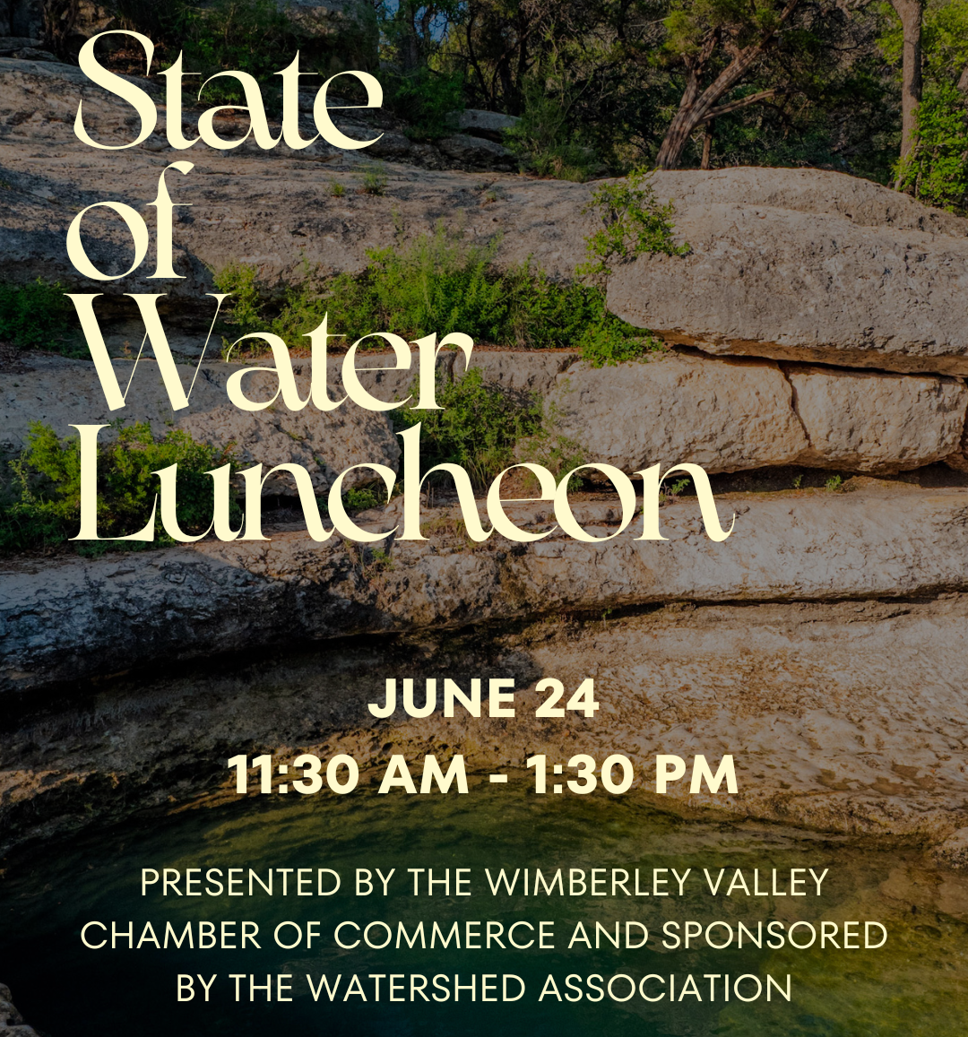
The Wimberley Valley Chamber of Commerce, in partnership with The Watershed Association, invites the community to the 2026 State of the Water Luncheon on Wednesday, June 24th, from 11:30 AM to 1:30 PM at the Wimberley Community Center.
Hosted by David Baker, founder of The Watershed Association, and Lindsey Derringer, Executive Director of the Wimberley Valley Chamber of Commerce, this annual gathering will bring together regional water leaders, experts, business owners, and community members for an important conversation about the future of water in the Texas Hill Country.
The event will explore current watershed conditions, regional water challenges, groundwater trends, and emerging solutions, including the role of One Water strategies in building long-term resilience for Jacob’s Well, our creeks and rivers, and our communities.
This event will focus on the critical State of Our Water:
- Jacob’s Well has remained at zero flow since November 2025.
- The Barton Springs/Edwards Aquifer Conservation District is experiencing the longest drought period in its history.
- Regional water demand is projected to more than double by 2050.
Keynote Speakers Include:
- David Baker - Executive Director Watershed Association
- Dr. Robert Mace - Executive Director and Chief Water Policy Officer at The Meadows Center for Water and the Environment
- Melissa Wolter - Watershed Coordinator for the Blanco Cypress Watershed Protection Plan
Panel Discussion:
- Mayor Jim Chiles Wimberley
- Mayor Debra Hines Woodcreek
- County Commissioner Morgan Hammer
- Dr. Robert Mace
- Melissa Wolter
The State of the Water Annual Luncheon is one of the largest and well-attended luncheons of the year.
Reserve your space now.
Sponsorship opportunities are still available.
Tickets: $25 for Chamber members | $30 for non-members
Purchase tickets at: Wimberley Valley Chamber of Commerce.
| | Jacobs Well:
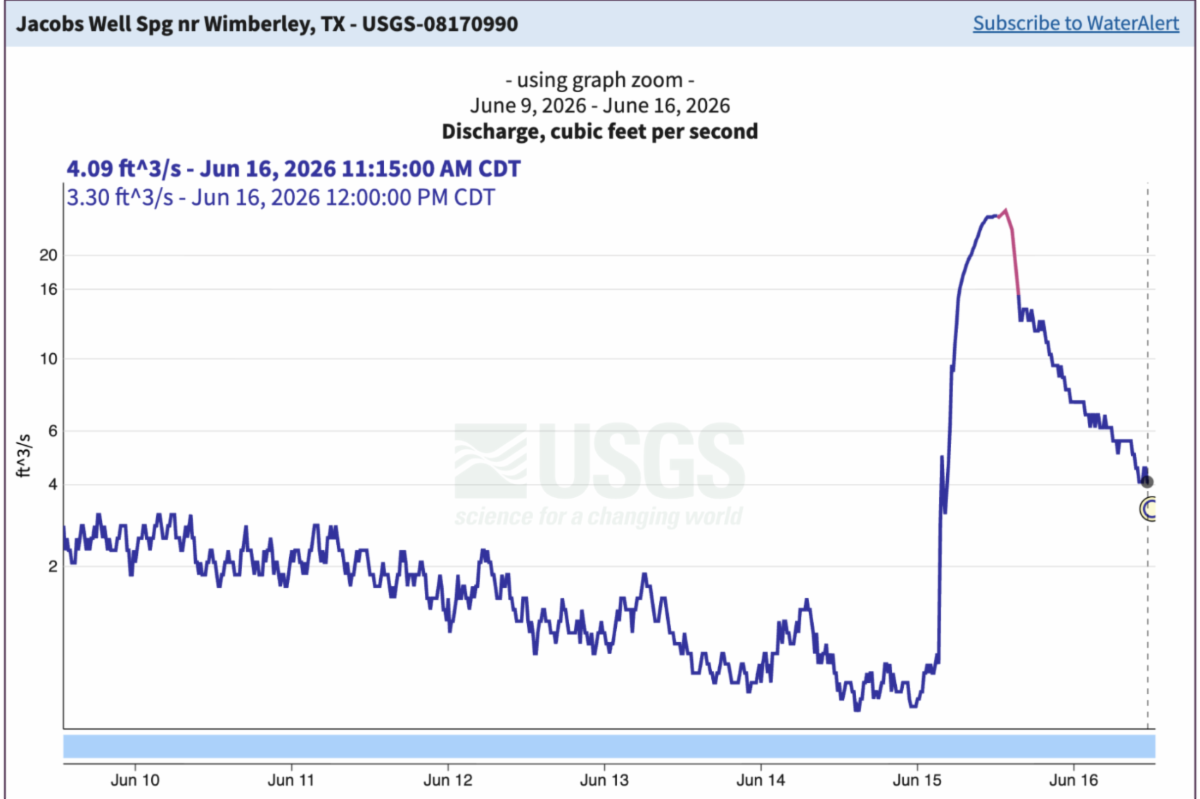
Recent Rains and A Short-Lived Recovery | The USGS gauge from June 9-16, 2026, shows a fragile system on the edge. Jacob's Well spiked from 0.25 cubic feet per second to 26 cubic feet per second in one rainfall event, then crashed back to 3.8 cubic feet per second within 24 hours. This extreme volatility reveals responsiveness to the rapid recharge but also the swift decline in flow as the aquifer reaches equilibrium behind the Jacob’s Well and Tom Creek Faults. Until annual recharge exceeds annual extraction, the aquifer will continue to decline, and the spring flows will remain vulnerable. | |
The USGS gauge from June 9-16, 2026, shows a fragile system on the edge. Jacob's Well spiked from 0.25 cubic feet per second to 26 cubic feet per second in one rainfall event, then crashed back to 3.8 cubic feet per second within 24 hours. This extreme volatility reveals responsiveness to the rapid recharge but also the swift decline in flow as the aquifer reaches equilibrium behind the Jacob’s Well and Tom Creek Faults. Until annual recharge exceeds annual extraction, the aquifer will continue to decline, and the spring flows will remain vulnerable.
Over the past four years (2022-2025), the Wimberley area received approximately 32-37 inches less rainfall than normal, essentially missing an entire year's worth of precipitation. Meanwhile, Aqua Texas pumped 237,925,138 gallons beyond permitted limits.
THE WATER BALANCE CRISIS
A few major rainfall events or even the promise of the coming El Niño may not restore the hydrological balance for the spring to flow consistently again. The Trinity Aquifer operates on water balance - the difference between recharge (water entering the system through rainfall) and extraction (water pumped out).
| |
For four years, recharge has been below normal while extraction has remained high or increased. This imbalance creates a cumulative deficit that a single rain event cannot rectify. The aquifer's water table has dropped significantly. Notably, less than one single foot of water level change at the Well is equal to 5 cubic feet per second and can start or stop the spring from flowing. Jacob's Well depends on that artesian pressure in the water table. Until annual recharge consistently exceeds annual extraction, the aquifer will continue to decline, and the spring will remain impaired and vulnerable.
In response to the ongoing imbalance, Jacob's Well went from flowing 10.29 cfs (2012-2021 average) to 0.91 cfs (2022-2025). The spring is not recovering flows because the aquifer has no reserve. A single rain event provides temporary relief, but without sustained recharge or reduced extraction, the spring returns to critical levels within days or even hours.
This system is fragile and sensitive to slight changes caused by pumping and responsive to rainfall. The spring flows only when conditions align perfectly - above-average rainfall and restraint in groundwater pumping. When over-pumping occurs during drought, the spring stops.
| |
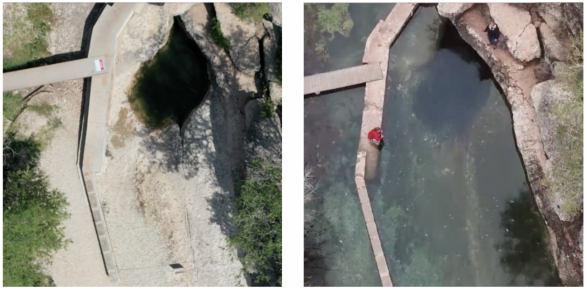
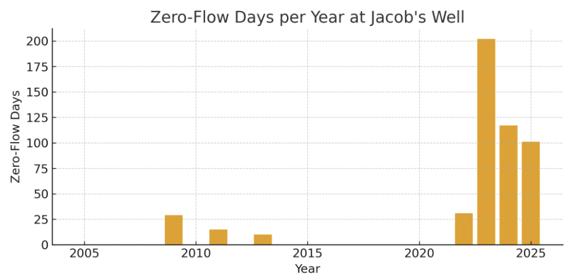
Jacob's Well has gone dry for more than 500 days in the past four years - more than all of prior recorded history. We are currently 3½ feet short on rain, and the aquifer is at historic lows. Given our present conditions, we need years of steady rain and to move large production wells out of the Jacob’s Well Groundwater Management Zone to begin to recover.
The June 2026 data is a warning. We must take action as a community to enforce sustainable groundwater management, to protect the recharge zone, and to implement sustainable growth policies.
| Making Sense of the Unknown:
A Day With Dr. George Veni at Karst Canyon Preserve | | This spring, the Watershed Association team spent the morning at Jacobs Well with one of the great minds of hydrogeology and karst. Pat Egan, the Watershed Association's Volunteer Coordinator and Land and Facilities Assistant, and Zane Porterfield, the Watershed Association's Policy and Outreach Coordinator, had the rare privilege of interviewing him on the land and learning from his fifty year study of our unique hydrogeologic system.
The Watershed Association’s work over the decades has been intrinsically intertwined with supporting the best scientific minds in the state. Without visionaries like Dr. Veni, this land would remain a mystery. Our organization has been devoted to filling the knowledge gap that governments and local leaders could not, and with 30 years of citizen science, commissioned studies, and policy initiatives, we have only just begun to understand the beauty and complexity of our waters. | | |
The Void Beneath Your Feet
Veni is a hydrogeologist who has spent five decades studying karst: the dissolving, fracturing, cave-forming landscape that underlies much of Central Texas and provides drinking water to millions of people. He runs his own consulting firm, served as president of the International Union of Speleology until 2022, and has testified before city councils, worked on every side of the regulatory table, and traced dye through aquifers on multiple continents. He is not, he will tell you, an expert on everything. But on the question of how water moves through limestone, and what it means, he is about as authoritative as it gets.
He describes his work with a line he has clearly used before, the kind of line that gets sharper with repetition:
"I'm a geologist who studies the absence of rock. I study nothing."
The joke lands because it is also exactly true. Karst is not a substance. It is what happens when a substance is removed. Rainwater picks up carbon dioxide and becomes weak carbonic acid. Soil respiration strengthens the acid further. The water moves into fractures in solid limestone, dissolving the rock slowly, making the passage a little wider. A wider passage captures more water, which enlarges it faster. The process is self-accelerating. When a conduit becomes large enough for a person to enter, it gets called a cave — though Veni is quick to note that the word is human-centric.
| | Land. Water. Connection:
What Pete Van Dyck Taught Us About Drought-Proofing Texas | | |
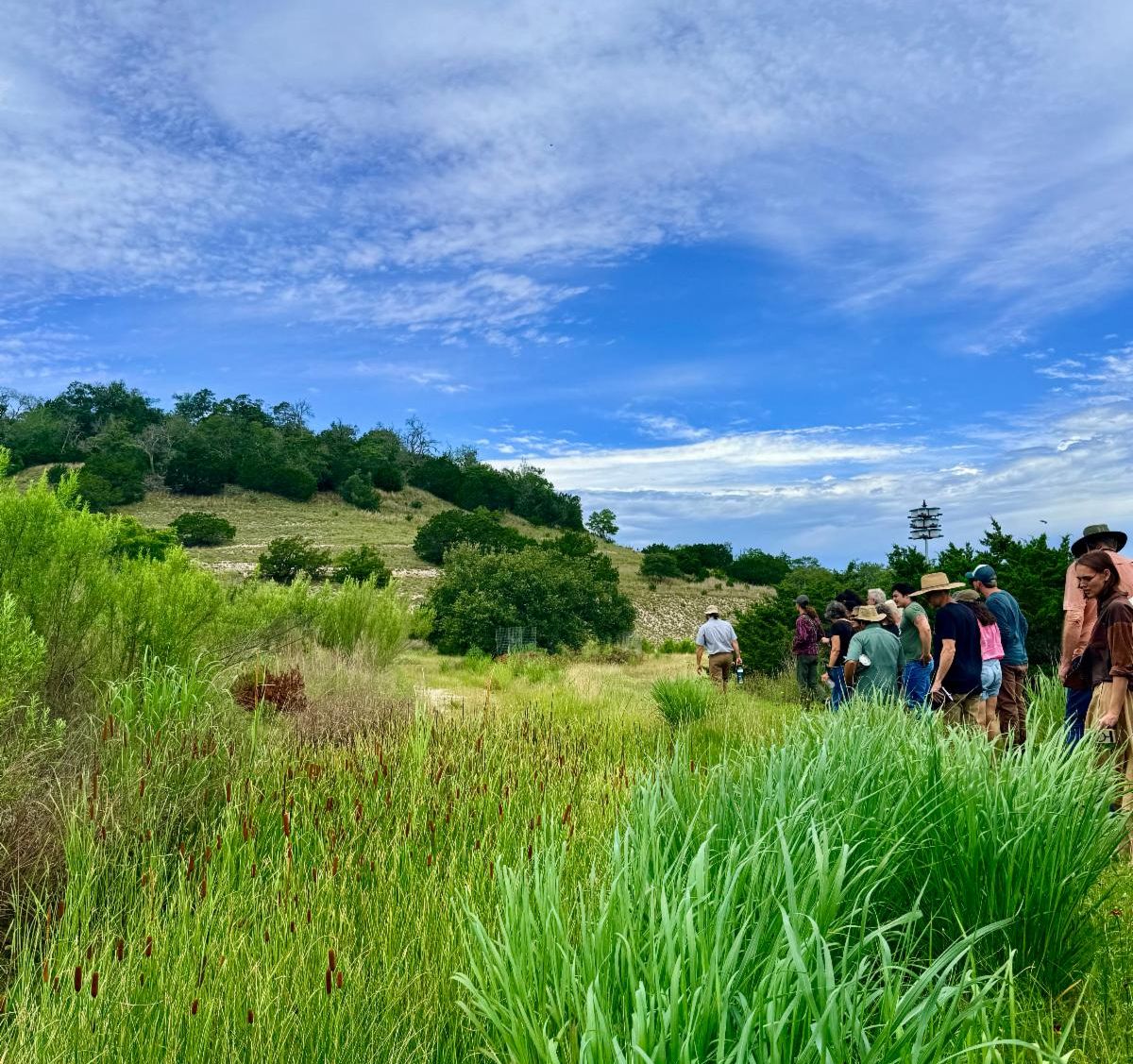
Last month, the Watershed Association continued our Land. Water. Connection series, an ongoing educational program to connect landowners, neighbors, and community members with the knowledge and tools to become active stewards of our aquifers, springs, creeks, and rivers. What better than a field trip to a living example of a regenerative oasis in Blanco? Pete Van Dyck of Van Dyck Earthworks & Design gave us a tour of his amazing 12-year project to catch rain on his hillsides, and the principles really spoke for themselves!
The relationship between rain, plants, and soil health.
Pete's presentation was an immersive experience that changed your whole perception. He showed the audience why drought and flooding can be mutually managed with the same strategies. To mitigate drought, we have to harvest as much rainfall as possible during the heavy downpours and store it in the soil, as high up in the landscape as possible. To mitigate floods, we do the same. We learned that for soils to absorb water, plants must be present.
An incredible fact: every 1% of organic matter in your soil has the ability to hold roughly 27,000 gallons of water per acre, the equivalent of a full inch of rain. Most Hill Country soils have around 1% organic matter or less. Increase that organic matter to 3%, and you've nearly tripled your land's ability to store. That's the difference between a landscape that speeds up a dangerous flood and one that drinks in water, slowly recharging the springs and aquifers we all depend on. Pete’s work in the Hill Country demonstrates a rapid regeneration approach - sometimes nearing that 1-3% increase in spongy topsoil in a single season, tripling the capacity of the soils to recharge your well, or protect your land from erosion.
| | | | |