E-Newsletter | September 18, 2020 |
|
On the Waterfront: Part I |
|
(A special thanks to Marge and Skip Motes for their exhaustive research on this and many other subjects in Newburyport’s history.)
The Newburyport waterfront has changed drastically in the 365 years since the first wharf was constructed in 1655.
The waterline originally came up farther, almost lapping at today’s Newburyport Art Association building. Beginning with simple wooden docks, the area soon became crowded with stout piers reaching far into the Merrimack. They supported a lucrative shipping industry that brought wealth and worldly influences to our port city.
The area we know as the Newburyport waterfront, was once simply a stretch of shore used by the local native peoples to catch and dry fish.
The original English settlers of Newbury arrived in 1635, but chose to use the protected bank of the Parker River as their docking area. Throughout the mid-17th century, Common Land along the river was initially controlled by 92 Newbury proprietors who had no interest in maritime trade. They preferred to stay insular, protecting their carefully curated Puritan social structure by eschewing outside influences.
It was not until 20 years after its founding that the town of Newbury “granted to Captain Paul White a parcel of land not exceeding half an acre…for to make a dock, a wharf and a warehouse, provided he do build a dock and warehouse as afore-said.”
At this time, the water’s edge would have reached almost to today’s Market Square and the dock may have been located near where the Firehouse Center for the Arts is now. White’s pier was followed slowly by the construction of more docks used for local trade, a practice that was judiciously controlled by town officials.
Long strips of land were reserved by Newbury as roads to and from the burgeoning harbor. In 1678, the town created the a “highway for the town’s use to the dock for to unlade hay, wood, timber, boards, or anything else which is produced in or upon the river.”
Despite the town’s careful efforts, these wharves and highways began the “improvement” of the waterfront which inexorably led to the development of Newburyport as a center of industry and trade.
The upriver, protected area also served as an ideal ship building location.
|
|
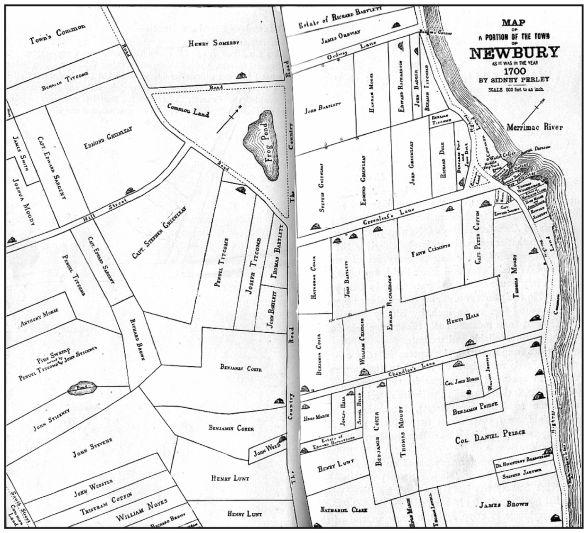
Detailed may of Newbury, circa 1700, drawn by Sidney Perley (1858-1928). Image courtesy of the Newburyport Preservation Trust. |
|
By 1705, shipyards were interspersed between the ever-growing number of docks and wharves. Newbury quickly rose to prominence, producing substantial numbers of new vessels, lagging only behind Boston and Charlestown, Massachusetts.
In 1764, the maritime-focused Waterside community separated from agricultural Newbury to form the new town of Newburyport.
At only 600 acres in size, the settlement was centralized along the bank of the Merrimack River. The town was founded on economic advancement, rather than religious zeal, and relied on foreign trade for its significant and swift development. Ships from Newburyport traded all over the world, making the waterfront active, densely populated and diverse.
|
|
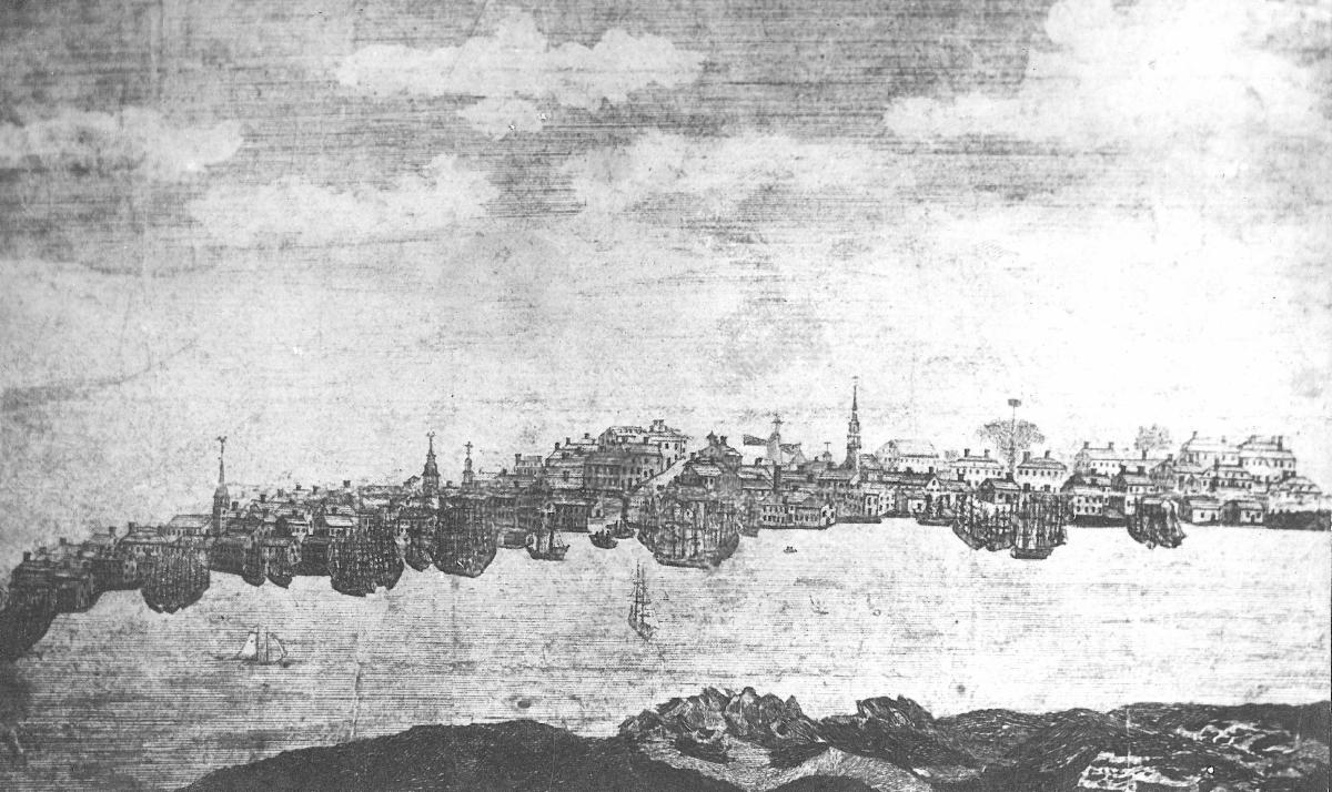
Engraving by Benjamin Tucker, circa 1796. From the collections of the Museum of Old Newbury. |
|
While embargoes beginning in 1807 and the War of 1812 weakened foreign trade and the Fire of 1811 damaged the local economy, shipbuilding in Newburyport boomed until the mid-1800s.
The imposing Custom House, built in 1834, and the large federal mansions along High Street, including our own Cushing House, are a testament to the success and wealth of the city.
Wharves and docks eventually became so dense that the waterfront stretched farther into the Merrimac River. They were flanked by buildings dedicated to the maritime industry such as ropewalks, sail lofts, warehouses, rum distilleries and counting houses. These flourished, grew and land was filled in, creating a bustling center of trade where there was once only water.
This industrial boom lasted until the introduction of steamships and railroads began to erode the power of the clipper ships, essentially changing the nature of the waterfront in the latter half of the nineteenth century.
Tune in next week to find out more about how the waterfront was changed by new technology.
(Editor's note: Emily Hoffman contributed to this story.)
|
|
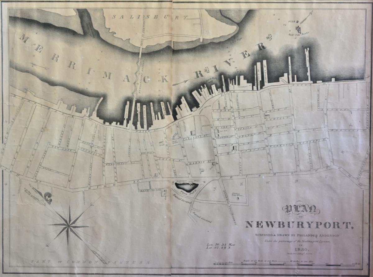
Newburyport waterfront circa 1830. From the collections of the Museum of Old Newbury. Photo by Bob Watts. |
|
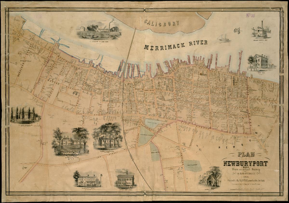
Newburyport waterfront circa 1851. Image courtesy of Norman B. Leventhal Map Center Collection. |
|
Tune in Today at Noon for "Yeat Yeat, Don't Tell Me!"
Jack Santos, Customs House Maritime Museum, and Colleen Turner Secino, Museum of Old Newbury, are back together for today's "Yeat Yeat, Don't Tell Me!"
Newbury-area's fastest half-hour of witty banter and historical trivia celebrates its 10th episode.
The show is an amalgamation of popular Q&A radio and TV game shows, presented in a Zoom format. Turner Secino observes, "It's a great way to learn about the Newburys and have a laugh or two."
Join us promptly at 12:00 p.m., today, September 18, 2020, by zooming in here.
|
|
Now Available: From Garden to Table |
|
Have you watched the fourth installment in our 2020 Garden Tour series of "virtual" explorations?
Naturally, we saved the best for last! Unlike our two-day tours customarily held at the start of the season, we were able to follow Steve and Amantha's lovely oasis from spring to harvest, sharing with you the bounty and beauty of their garden.
Visit us here to enjoy previous installments that feature an informative segment on composting and two very different takes on what makes for an ideal backyard retreat.
|
|
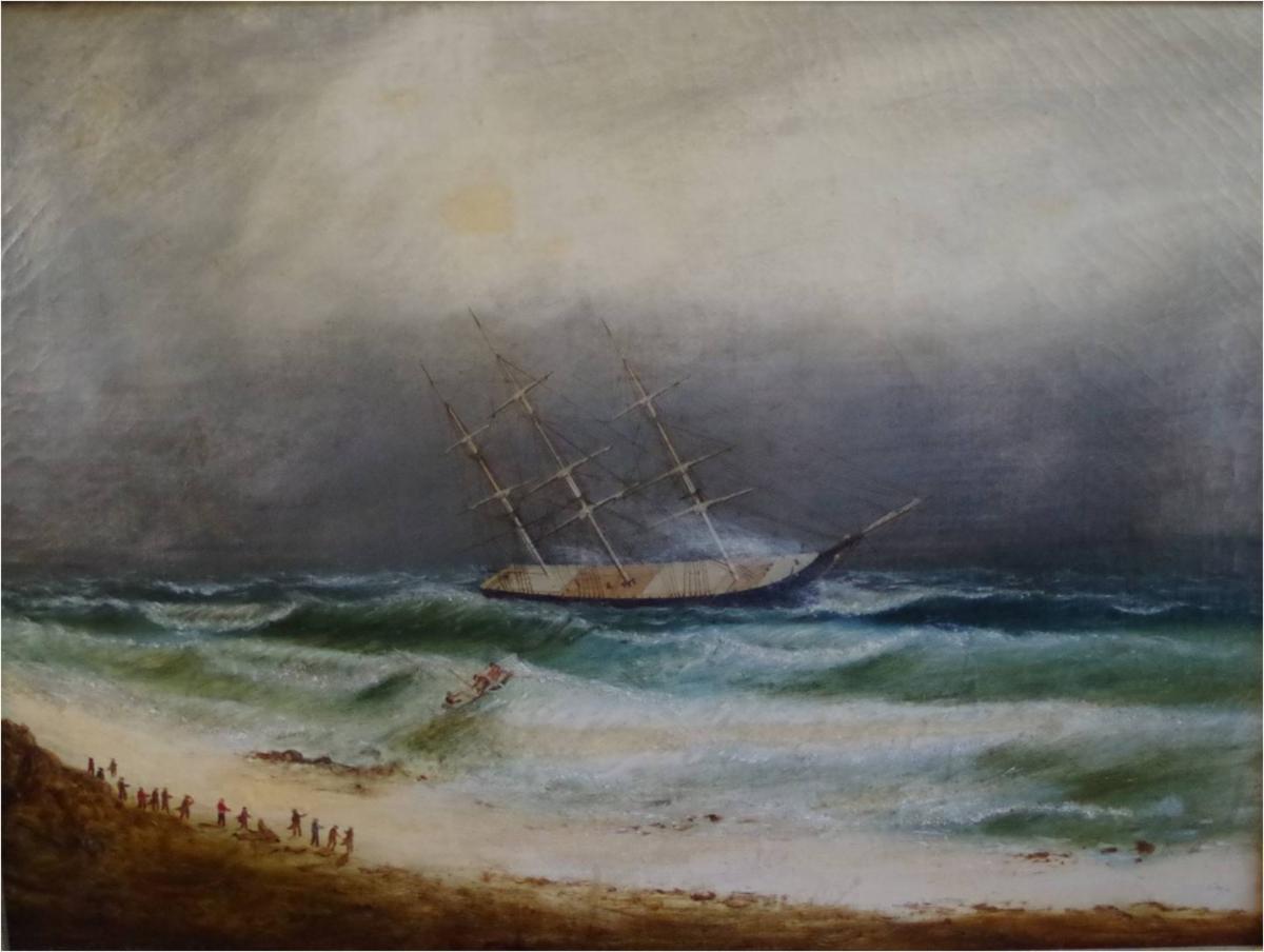
Puzzle Me This...The Sea was Angry that Day
This painting is one of a pair depicting the Ship Burmah in distress during a storm on February 21, 1837. The ship's master, Captain Deford, was bound from New Orleans to Portsmouth, New Hampshire with a load of cotton when it went ashore on a reef near Plum Island in Ipswich Bay.
Jacob Knapp Lunt, a Newburyport pilot, recognizing the imminent danger that threatened the ship, took a boat from the shore to rescue her, risking his own life in the process. He succeeded in getting her off the reef and took her into Salem Harbor. The vessel and cargo were insured for $90,000. For Lunt's valuable service, the underwriters paid him the sum of $300.
About Rescue of the Ship Burmah off Plum Island, 1865; oil on canvas by Clement Drew (1806-1889).
Artist Clement Drew was born in Kingston, Massachusetts. He maintained several studios in Boston between 1827 and 1873 and also acted as an art dealer and framer. Drew was a prolific painter of marine scenes, often illustrating ships in distress on the high seas.
Bequest of Wilhelmina and Sylvia Lunt.
Click on the image to begin.
|
|
Something is Always Cooking at the Museum
You had me at bacon, Ruth Foskett! This quick, simple and yummy side vegetable sounds delicious. In fact, we bet it could work with Brussels sprouts, broccoli and even steamed butternut squash, to name a few other possibilities.
Apricot-Glazed Green Beans
2 pounds green beans, trimmed
6 slices bacon
1/4 cup olive oil
4 cloves garlic, thinly sliced
1/4 cup apricot jam
3 tablespoons white wine vinegar
Salt and ground black pepper to taste
Boil beans in salted water until just tender, about 3 to 4 minutes. Cook bacon and crumble. Wipe out pan. Add olive oil and heat to medium-high. Add garlic; cook about 2 minutes. Stir in jam and vinegar. Add green beans and toss to coat. Season with salt and pepper. Fold in bacon. Serves 6.
|
|
During this difficult period of COVID-19, we rely on your support more than ever. We are working to reschedule many of the programs that we have had to postpone, as well as develop new, online programs for you to enjoy and keep us connected. We hope, if you are able, that you will consider a donation to the museum. Thank you for your continued support.
|
|
Museum e-Newsletter made possible through
the generosity of our sponsors:
|
|
|
Museum of Old Newbury
98 High Street
Newburyport, MA 01950
978-462-2681
|
|
|
|
|
|
|
|