Please, forward this email to your
interested friends!
|
|
To view email in your browser as prepared with images, click here..
|
|
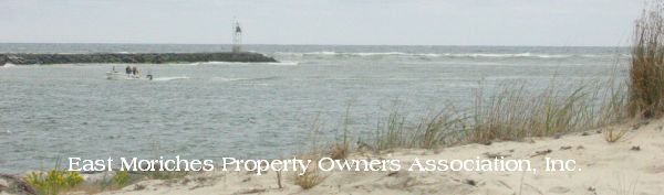
August 17, 2023
Contents
79 ACRES OF EAST MORICHES AT RISK!
.....STATUS -- The Preserve site
.....STATUS -- Spadaro Airport
.....STATUS -- Lufker Airport
.....A responsible land use solution
Issues on The Preserve at East Moriches
Eastport Shopping Center
The problem, and how to fix it
|
|
79 ACRES OF EAST MORICHES AT RISK! |
|
It has been too long since our last newsletter; reasons for that are explained below in the last article. This newsletter is long because it involves three adjacent properties with intertwined histories and possibly futures. They total a whopping 79 acres and are on both the Montauk Highway and the Riverhead Road. YOU need to help the owners and the Town decide what happens. To let the Town know, contact them. But first read on to understand the situation.
|
|
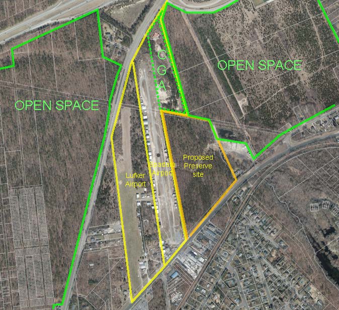
Lufker Airport on the left, Spadaro Airport in the middle, and at the right the property once owned by Spadaro on which the Preserve PRC is proposed.
Click/tap on all images for larger versions.
|
|
EMPOA has reported on these three properties previously. Prior newsletters are linked at the bottom of this one. Let's bring things up to date and look at the current status of these properties, how they are potentially connected and what uses would be best for them. Then we will discuss issues with respect to the pending site plan application for The Preserve at East Moriches. |
|
STATUS -- The Preserve site |
|
In December 1988, the Town Board, in its purported wisdom, rezoned 23 acres of woodland where the Preserve is proposed from B Residential to Planned Retirement Community (PRC). In 1998, Bart Spadaro, owner of the adjacent, functioning airport purchased the property to use it for airport improvements. He obtained a grant from the Federal Aviation Administration which, pursuant to its regulations, imposed a lien and many restrictions on the property for a number of years. The contemplated airport improvements never happened, and in 2011 Spadaro sold the property to an affiliate of The Northwind Group.
Northwind has been, and is, an active development company in Brookhaven and elsewhere. Among its many projects is the PRC located immediately south of the railroad tracks in Eastport.
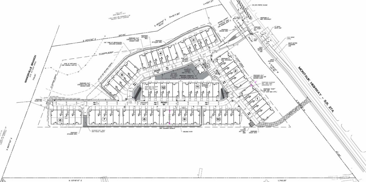
In 2013, Northwind submitted a site plan application for building a 70-unit PRC on the 22-acre property. There would be five or six attached units of approximately 1,800 square feet in 12 buildings. The development would have minimal common and recreational areas including a community building of just 1200 sf.
|
|
The project got tied up for years by the FAA restrictions and the need to find and buy septic credits. Things seemed quiet in recent years, but apparently there was progress on the site plan application. As a surprise to EMPOA, the application appeared on the Planning Board’s agenda for Monday, August 7.
EMPOA requested additional time to review and present a position on the application. For that and other reasons, after Northwind’s attorney presented its arguments for the application, the hearing was held open and will be continued on August 28.
So on Monday August 28 at 4:00 p.m., any resident may address the Planning Board with his or her views on the project. Written comments may also be submitted prior to the hearing. EMPOA has identified a number of issues in these plans that need to be resolved; they are listed in an article below., along with contact information for the Board.
|
|
STATUS -- Spadaro Airport |
|
The ownership and future uses of this property are in flux. On Bart Spadaro's death in 2010, the property passed to a trust he had set up for the benefit of his daughters. The Town spent several years in litigation with the trust seeking a court order prohibiting airport operations. The court proceeding was ended by a stipulation between the Town and the trust. In February of this year the trust sold the property to FBF Seatuck LLC (one of whose owners seems to be a builder); its owners have wanted to find an acceptable use for the property and considered at least two ideas that we know of.
-
An airpark, that is, 24 3-story homes, each with a hanger, built along the existing runway plus some commercial uses.
-
A Muslim cemetery. This was the idea of a particular investor who has shown interest in the property. The investor pointed to the absence of a Muslim cemetery on Long Island. (There are, however, Muslim sections in other cemeteries.)
An airpark would require a zoning change by the Town Board, and perhaps enactment of a new use category in the Town code. A cemetery is allowed in A1 Residential Districts, but only with a special permit granted by the Town Board. There would be a public hearing before before each of these possible steps.
The LLC, as far as we know, has so far neither moved forward on an airpark nor sold to the investor interested in the Muslim cemetery. As of 8/14, no deed transferring the property has been recorded.
|
|
The deaths of Lou Lufker in 2018 and later his wife Dorothy left the property in the hands of their 10 children. There reportedly was some interest in continuing operation of the airport, but the children have been looking for a buyer. They found at least two, and EMPOA’s Board met with them to discuss their proposals.
|
|
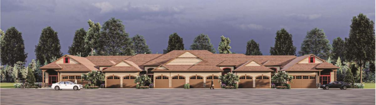
- One buyer proposed a large, towering, indoor sports facility that would be like one in Danbury, Connecticut, which you can see at the right.
- The other wanted to build a 144-unit PRC, which he reduced by 45 units after our discussion. Site plans for both are on EMPOAweb.
|
|
|
EMPOA’s Board expressed significant reservations with respect to both projects and neither seems to be proceeding.
We understand that the Town is looking at the possible acquisition of the property to be held as open space.
|
|
A responsible land use solution |
|
The role of a Town in land use is not just to enact rules and sometimes play cop to see to their enforcement. Its role should be to foster, encourage and facilitate land use (and non-use) that is good for the community. Here, it can be argued, the Town is failing.
What we will end up with, if current developments take their course, is a 70-unit PRC abutting Brookhaven-owned open space and the Pine Barrens Compatible Growth Area. Next to it would be an airpark or a cemetery. The airport or cemetery would then be next to open space. That open space would abut residences and an undeveloped lot on its west. This would be hodgepodge land use! And fostered by the Town Board!
What would surely make more sense would be to have the existing Brookhaven open space to the east contiguous with any new open space, thereby forming a larger block of open space. That is a recognized environmental principle. So the Preserve PRC site should be open space. The two airports could have other uses, or they could also be held as open space. It would be helpful to East Moriches residents to have more of this 79 acres purchased as open space.
You can be involved in resolving how these three properties are used by giving your comments to Supervisor Romaine and Deputy Supervisor and Councilman Panico, with copies to Planning Director Don Hohn. Please also copy EMPOA. Here i s a link to open an email. The link won't work with all systems, so here are the addresses: eromaine@brookhavenny.gov, councilmanpanico@brookhavenny.gov, DHohn@brookhavenny.gov, EMPOAonline@gmail.com
|
|
THE PRESERVE AT EAST MORICHES
Planning Board Hearing
August 28, 4 pm, # 8
|
|
The Preserve site plan application hearing will continue a week from Monday. How do we address that? The proposed plans (second image from top) bring to light a variety of questions and issues.
Here are some:
- Does applicant plan to rent or sell the units? The papers submitted don't explicitly answer the question, although there is a hint they will be sold as condos.
-
The impact the project will have on most of us is the loss of woodland along the Montauk Highway between East Moriches and Eastport villages. The plans call for leaving the existing woods for 100 feet back from the highway, except for the 55-foot wide access roadway and a 20-foot wide roadway with a crash gate for fire and other emergency vehicles.
-
A 100-foot buffer sounds good superficially, but the trees in that “buffer” are deciduous so for most of the year drivers and passengers on the highway will be able to see right through them, making the buildings about 115 feet back from the highway quite visible. Shouldn't the buildings be screened with evergreens? Shouldn’t they be planted thoughtfully, and not just in a row?
-
The plans call for the emergency roadway to be made of grass block. That would camouflage it as much as possible and be environmentally preferable. At the August 7 hearing however, applicant’s attorney said that the fire marshal was insisting that it be asphalt. We hope to be looking into this.
-
There are stores, a restaurant and services on the other side of the Montauk Highway within walking distance. There are sidewalks on the south side of the highway directly across from this location. A crosswalk would help residents get to the nearby stores and services.
-
The design of the buildings seems tasteful enough, but the facades along the roadways are dominated by garage doors. Since each unit has two garages, the driveways are 17 feet wide and only the smaller part of the 30 ft wide frontage is left for a residential appearance, and the renderings show the front doors blocked by deciduous trees.
|
|
-
Besides the garage spaces and room to park on the driveway aprons in front of the garages, there are just nine other parking spaces provided near the clubhouse. Will there be enough parking spaces if someone is having a party? The roadways are 24 ft wide and two-way.
- Town Code § 85-300 calls for this type and size facility to have 14,000 square feet of outdoor recreation areas. A pool is not proposed. The plans show a 7,800 square foot area with picnic tables, a 1,460 square foot area with a bocce court and a 990 square foot area for horseshoes, totaling only 10,250 square feet of “recreation space”. The plans also show designated walking paths--but see the next issue as to whether the paths should be counted.
-
A plan that combines the two small areas with the largest one might very well be preferable. Then residents of the PRC could socialize and recreate together in a larger space.
-
However, the applicant plan already utilizes nearly every square inch within the building envelope, so rearranging buildings to make a larger recreation space would be difficult. This may be another indication that too many units are proposed for this lot with its large, unbuildable wetlands area.
-
The problem with the proposed walking paths is this. They are located immediately behind residential units. Very immediately. The walkways abut the 6-foot deep patios behind each unit. Seniors having a morning coffee, mid-day snooze or late afternoon cocktail might not enjoy runners or strollers passing by so closely.
-
There is a 250 ft deep buffer on the southwest side of the property. Wouldn't walking paths be better located there?
-
The 250-foot buffer comes from a 1989 covenant entered by the then-owner of the property to make the PRC zoning effective. The covenant was included because of the then-operating adjacent airport. It contains an exception for the sanitary disposal system. The plans show the buffer area but have large cut outs for the sanitary system. The need for so much deforestation is not clear nor is there any evident reason why new trees cannot be planted.
-
The property is not level. As a result, there are a number of retaining walls shown on the plans, but the plans do not indicate how high they are or what protection there might be at the tops of them to prevent someone from falling. A long retaining wall is located behind a number of the units and is only 10 feet from one unit’s back door. Safety is a concern.
-
The plans specify the types of streetlights that would be installed, but do not give the color or intensity of the light. The lumens and Kelvin rating are needed to properly assess the plans.
- There is a significant wetland area in the northeastern corner of the property. The headwaters of Little Seatuck Creek are there. Presumably the risk of runoff going into the wetlands and then the creek and bay has been assessed, but that is not clear from the plans.
What do you think? If the town is going to allow this PRC to be built, what changes should be made to the proposed plans? You can let the Planning Board know by appearing at the hearing and speaking or by submitting written comments in advance. Since the Planning Board will be holding its working session for the August 28 meeting on this coming Wednesday, August 23, your comments would have the most impact if submitted to the Board's secretary on or before August 22.
|
|
Another active project
EASTPORT SHOPPING CENTER
|
|
EMPOA's Board has also met with Eastport Regency LLC, the new owner of the King Kullen shopping center in Eastport. They want to add a building right on the corner of Montauk Highway and Eastport Manor Road, next to the small park, to house a restaurant and another facility (retail or office). We made numerous comments for improving the plans. After our Zoom meeting, they did come back with a somewhat improved plan but continue to want the pad building by the road. The plans we have reviewed are on EMPOAweb; the link is at the bottom of this newsletter.
On June 1, the owner filed an application for site plan approval. The papers will be on the same EMPOAweb page once received.
|
|
The problem, and how to fix it |
|
Back to the problem raised at the opening of this newsletter. Why haven't EMPOA newsletters been coming out more frequently? The answer is quite simple. We need residents who are interested in land use issues to come forward and volunteer time.
Keeping track of land use activity in the Town (and sometimes in the County), compiling information and documents received, analyzing the information received and presenting current issues in a newsletter is very, very time-consuming. Help is needed. Without it, we won’t be able to keep preparing newsletters, or conferring with development proponents, or submitting positions to Town boards, or appearing at land use hearings as we have previously tried to do.
There are pending applications not covered in this newsletter that need to be reported in another newsletter. Work has to be done to get it out.
|
|
Unlike previous ones, this newsletter has few links to original and supporting documents. However they can be viewed on EMPOAweb pages for each project. The history of a given project can be seen to some extent from prior EMPOA newsletters and articles. Here are links to newsletters and documents. |
|
To make a difference, STAY involved! |
|
SPREAD THE WORD . . . SHARE THIS EMAIL ON SOCIAL MEDIA |
|
|
|
|
|
|