|
COLUMNS
GIS Tips & Tricks — Need Help Making DEMs from Lidar? Here are Three Workflows
Al Karlin, Ph.D., CSM-L, GISP, Anusha Chaudhary, M.S., and Prince Lawson M.Sc.
|
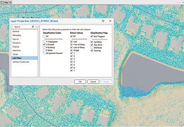
| |  | For those who have been following this column over the past several years, you know that many of the Tips & Tricks originate with students from my GIS classes. This month’s Tips & Tricks originated with students attending the weekly Florida Regional “brainstorming” sessions on Wednesday mornings. The students with one of the Florida Student Chapters are engaged in a UAV workshop collecting lidar data. The workshop covers flight planning and preparation, ground control, data collection, calibration, and LAS classification, but stops short of processing the LAS data into a Digital Elevation Model (DEM). LAS files store lidar point-cloud data, including each point’s geographic coordinates, elevation, return information, and classification attributes. A DEM is a digital, raster-based representation of the bare-earth surface, where each grid cell stores an elevation value. It depicts terrain features such as hills, valleys, slopes, and drainage pathways while excluding above-ground objects such as vegetation, buildings, and other structures. During the workshop, a question came up, how to construct a DEM from LAS data using ArcGIS Pro. So, I suggested that we all collaborate on a column describing workflows in ArcGIS Pro and two open-source GIS packages, QGIS and CloudCompare.
| |
GNSS Applications in Earth and Space Observations: Challenges and Prospective Approaches
Dileep Kumar Gupta and Abhay Kumar Singh, editors. Microsatellite Remote Sensing, GNSS, and Applications series, with Josaphat Tetuko Sri Sumantyo as series editor. CRC Press (Taylor & Francis Group), Boca Raton, FL, 2025. 388 pages. ISBN 978-1-032-71243-7 (hardcover). eBook ISBN 978-1-032-71244-4.
Reviewed by Brian Weaver, PhD, Assistant Professor, Oregon State University, College of Civil and Construction Engineering, Geomatics, Corvallis, Oregon, USA.
Global navigation satellite systems now reach well beyond positioning and timing into Earth and space observation, and this edited volume sets out to map that role across three application areas: climate studies, disaster management, and space weather monitoring. Published in the CRC Press series Microsatellite Remote Sensing, GNSS, and Applications, it collects twenty-seven contributed chapters and is aimed at graduate students, researchers, and practitioners in remote sensing, the Earth and space sciences, geophysics, climatology, and disaster management. The editors, Dileep Kumar Gupta and Abhay Kumar Singh, work in remote sensing and space weather physics, and most contributors are drawn from the Indian GNSS and ionospheric research community. The topic is timely and the interdisciplinary scope is welcome. What undermines the result is unevenness in accuracy and in editorial control within the first several chapters, to a degree that limits the book’s value as a stand-alone reference.
| | |
*Open Access
A Supervised Strategy for Object-Based Spectral Unmixing
Xinyu Ding, Chengyuan Zhang, and Qunming Wang
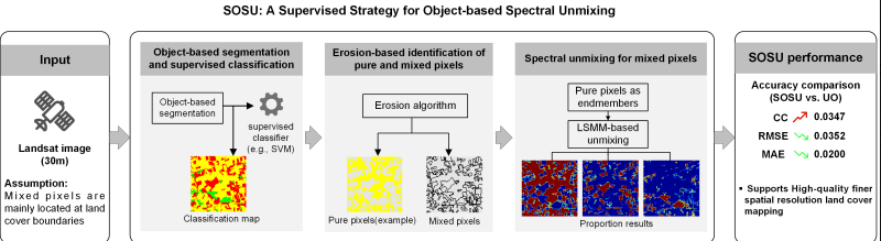
| Spectral unmixing is a technique to predict the proportions of land cover classes within mixed pixels. The proportions can serve as inputs for land cover classification at finer spatial resolutions (i.e., by subpixel mapping [SPM]). To achieve high-quality finer spatial resolution land cover mapping, during the spectral unmixing process, it is necessary to accurately identify land cover boundaries, which are typically represented by mixed pixels. The recently proposed unsupervised object-based subpixel mapping model (UO-SPM) incorporates object-level information into spectral unmixing. However, its performance is limited by uncertainties in unsupervised clustering and the automatic threshold segmentation. In this paper, we proposed a supervised strategy for object-based spectral unmixing (SOSU). | | |
Three-dimensional Building Reconstruction from Airborne Lidar and Optical Imagery with Optimized Energy Weighting
Xiangfei Wang, Bo Xu, and Xin Li
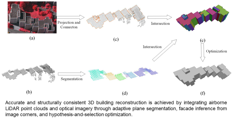
| | The application of three-dimensional (3D) building models has expanded rapidly in recent years. Airborne lidar point clouds and optical images are two primary data sources for building reconstruction and provide complementary geometric and radiometric information. However, reliable 3D building reconstruction from the integration of both modalities remains challenging due to noise and occlusions in the data. To address these issues, this paper proposes a hypothesis-and-selection–based building reconstruction method that integrates airborne lidar point clouds with optical images using manually annotated image corner points. | | |
Development of a Ground-based Large-scale Rotating Photogrammetric System
Chunmei Li and Jiuyun Sun
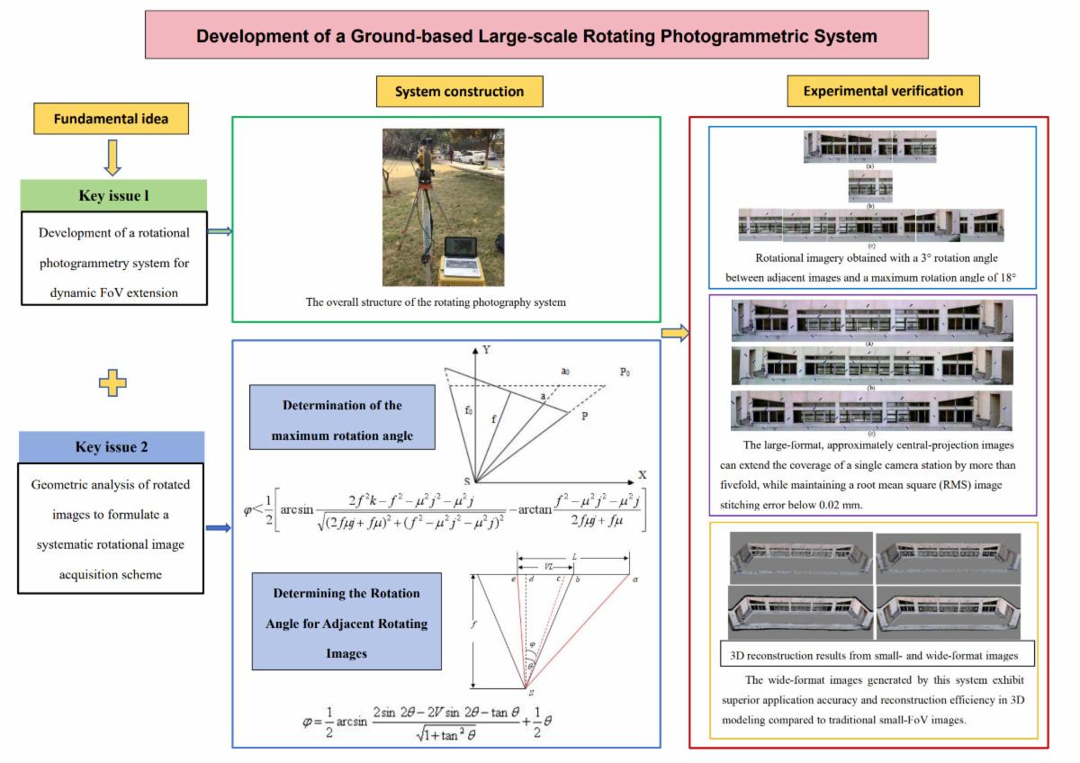
| | To address the limited field of view (FoV) of digital cameras in close-range photogrammetry, this study develops a novel, ground-based large-scale rotating photogrammetric system by integrating engineering surveying principles with photogrammetric theory. Results demonstrate that the approximate central projection images generated by this system can expand the coverage of a single camera station by more than five times while maintaining a root-mean square image stitching error less than 0.02 mm. The wide-format images generated by this system exhibit superior application accuracy and reconstruction efficiency in three-dimensional modeling compared with traditional small FoV images. | | |
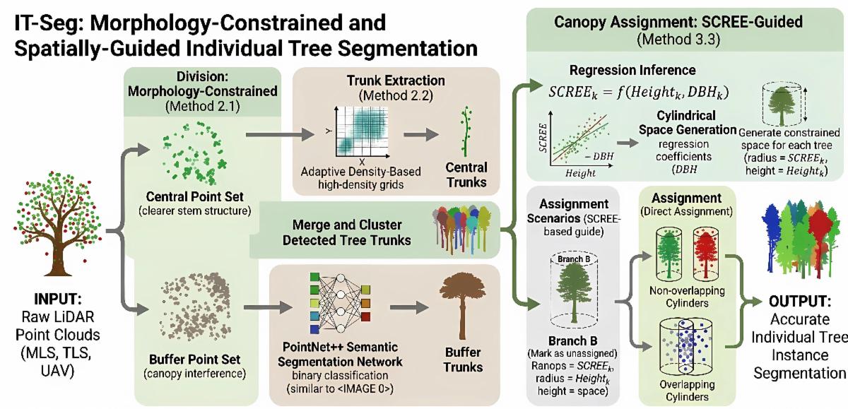
*IT-Seg: Morphology-Constrained and Spatially Guided Individual Tree Segmentation from Terrestrial and Mobile Point Clouds
Maolin Chen, Hanwen Yin, Zhiqing Zhang, Huan Zhang, and Liming Bo
| | Individual trees are essential components of forest ecosystems, and accurate tree-level segmentation provides a crucial foundation for forest ecosystem modeling and biodiversity assessment. We propose a novel point cloud-based individual tree segmentation method guided by morphological prior constraints and single-tree canopy radiative effective extent (SCREE), a metric used to define the canopy boundary for each tree, computed from high-dimensional features output by a network. | | |
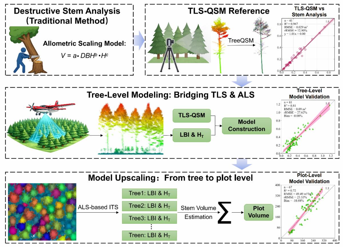
Hierarchical Integration of Multi-Source Lidar for Forest Volume Estimation across Individual Trees and Plot Scales
Denuo Gu, Yong Pang, Liming Du, and Dan Kong
| | Accurate stem volume estimation remains contingent on an analytical tree (i.e., tree felled and sectionally measured to obtain reference stem volume) as the calibration benchmark for remote sensing and allometric equation, thereby limiting scalability and operational efficiency in large-scale forest carbon assessment. To overcome this bottleneck, we propose a hierarchical integration framework for multi-source lidar-based stem volume estimation, termed “hierarchical integration of volume estimation” (HIVE), which establishes a lidar-driven estimation chain linking individual trees to plot-level assessments. | | |
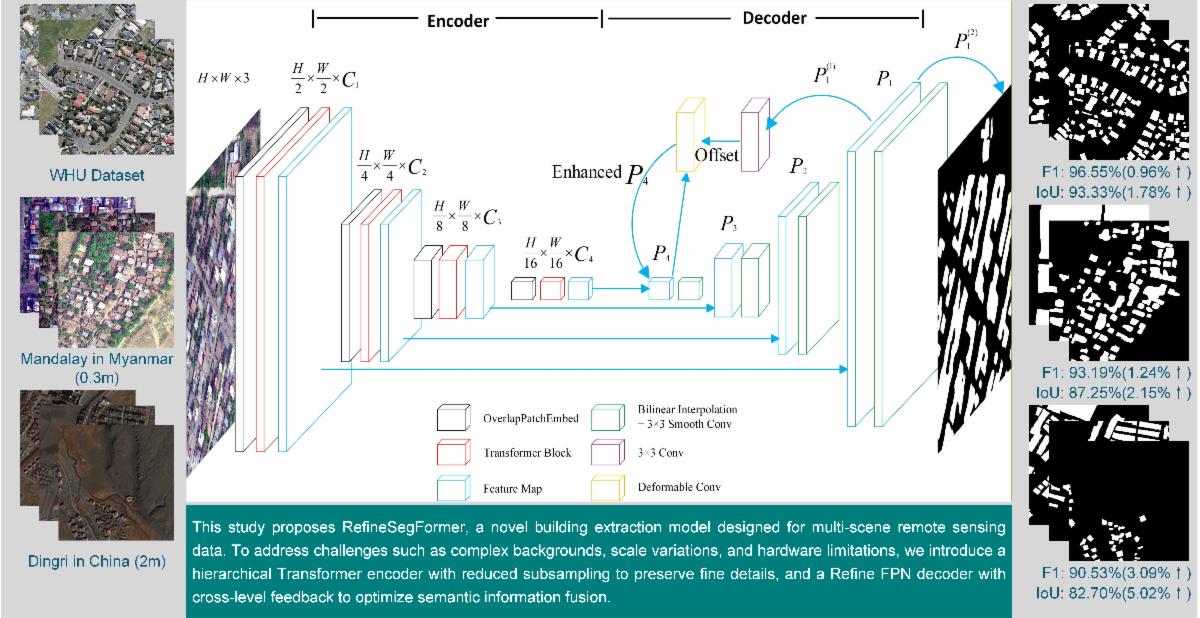
Building Extraction Model and Application from Multi-Scene Remote Sensing Data
Gangyu Yang, Wei Zhai, Jincheng Li, and Yingying Cao
| The extraction of building footprints based on high-resolution remote sensing images is widely used in many fields such as land survey and urban planning, and high resolution also brings complex background information. In order to improve the effectiveness of building footprint extraction, this paper proposes a RefineSegFormer that combines a hierarchical transformer encoder and a cross-level feedback Refine feature pyramid network implemented through deformable convolution. | | | | |