|
Columns
GIS Tips & Tricks - Using Full Motion Video (FMV) to Reveal Hidden Landscape Features, Part 1
By By Paul A. Pope, Ph.D.; Richard Pratt; Dane Coats; and Al Karlin, Ph.D., CSM-L, GISP
| |
One of the most common geographic information system (GIS) tricks to help visualize terrain features within a digital elevation model (DEM), is to generate a “Hillshade.” Esri™ ArcGIS Pro locates the Hillshade tool in multiple toolsets. Similar tools are available in QGIS, Global Mapper™, and most GIS software packages. A common feature across these GIS packages is that they all permit the user to specify a sun direction (azimuth), usually defaulting to 315º (West-North-West) and the sun altitude (inclination) in the sky, usually defaulting to 45º (local 1000h) from the horizon. Adjusting these parameters produces different shaded views which, in turn, can reveal different features in the DEM.
| | |
PE&RS Special Issue Call for Papers
Please visit https://my.asprs.org/pers (right hand column) for more details on each Special Issue Call for Papers.
- A New Era of Earth Observation: Applications of Google DeepMind’s 10‑m AI-Generated Remote Sensing Embeddings of the Planet Earth
- Large Language Models in Remote Sensing: Across Different Modalities
- Advances in SAR Data Analysis: Methods and Applications for Earth Observation
- Lidar and Photogrammetry for Mining
- 3D Reconstruction and Applications of Urban Scenes
| | |
*Denotes Open Access paper
Special Issue Introduction — Hyperspectral Narrowband Imaging Spectroscopy: A New Paradigm for Earth Observation
Prasad S. Thenkabail, Itiya Aneece, and Pardhasaradhi Teluguntla
| | |
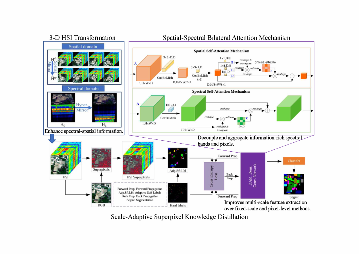
Scale-adaptive Knowledge Distillation with Superpixel for Hyperspectral Image Classification
Shuang Dong, Ying Li, Ming Xie, and Tingting Han
| | Hyperspectral image (HSI) classification is a critical area in remote sensing with broad applications in geoscience. While deep learning methods have gained popularity for HSI classification, their potential remains underexplored due to limited labeled data. To address this, we propose a scale-adaptive knowledge distillation with superpixel framework that trains deep neural networks using unlabeled samples. | | |
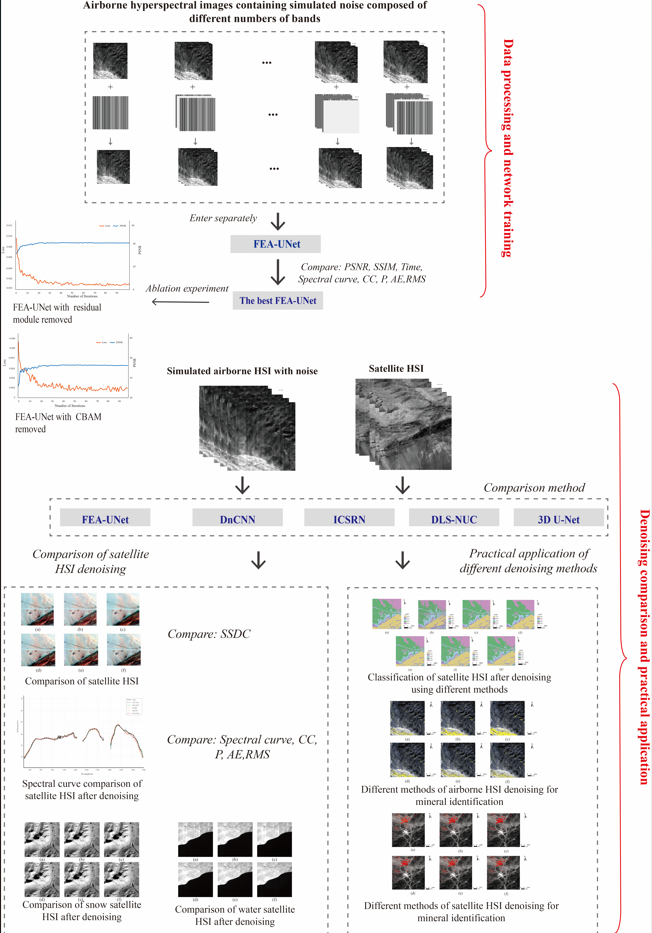
Stripe Noise Removal of ZY1-02D Hyperspectral Images Using an Improved Three-Dimensional U-Net Network
Ruoheng Gao, Xinfeng Dong, Na Li, Jing Cui, Tongtong Li, Jingkai Wu, Wei Bai, and Rui Zhang
| | The ZY1-02D satellite, equipped with China’s first civilian hyperspectral payload, provides valuable data for remote sensing applications. However, its hyperspectral images (HSIs) are often degraded by stripe noise, significantly limiting their practical utility. Traditional denoising methods are challenged by the complex spatial and spectral characteristics inherent to HSIs, frequently resulting in compromised image quality. Fusion residual block and attention mechanism U-Net (FEA–U-Net), a novel three-dimensional destriping network, is proposed to eliminate stripe noise in hyperspectral imagery. | | |
An Improved Manifold Learning Algorithm for Dimension Reduction of Fusion Data for Multispectral and Synthetic Aperture Radar Images
Zezhong Zheng, Jingfan Huang, Shuang Yu, and Zhenlu Yu
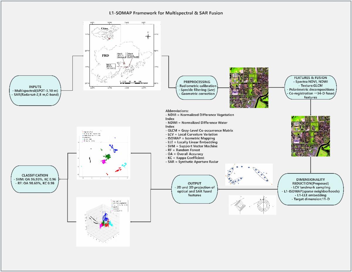
| | In the application of remote sensing data, the data obtained by a single sensor often cannot meet the actual needs, because the information contained in these data is often limited. Data fusion can improve the availability of these data, but it also brings the problem of information redundancy. In this paper, a whole set of multi-source remote sensing image-processing frameworks was constructed first and aimed at the problem of neighborhood selection in an isometric mapping (ISOMAP) algorithm; an improved ISOMAP algorithm based on the L1 norm (a sparse optimization technique that minimizes absolute value sums) was proposed to mine the inherent low-dimensional structure of multi-source remote sensing data and reduce the dimension of the data. | | |
Remote Sensing Image Denoising Network Based on Locally Enhanced Window Transformer
Shaohua Zhang, Wenyun Li, and Hefang Bian
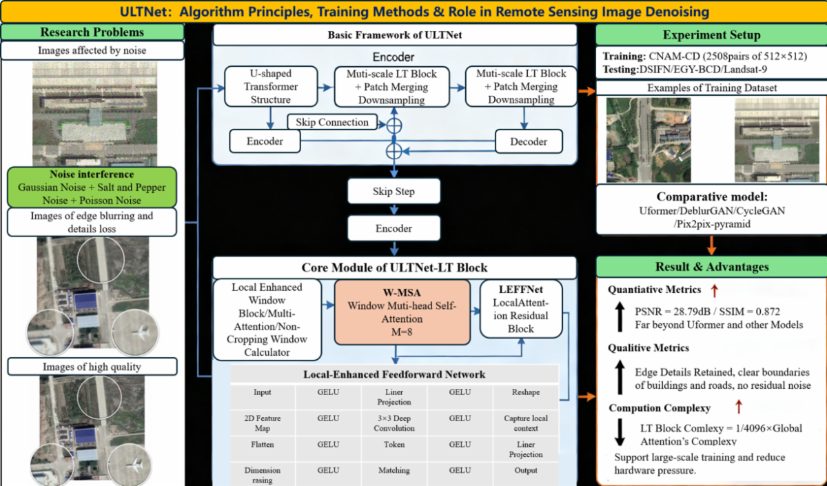
| | Remote sensing images serve as indispensable and pivotal carriers in diverse fields, including natural resource management, ecological environment protection, and urban–rural construction planning. Acquiring high-quality remote sensing images is particularly critical for practical applications. However, limitations such as adverse weather conditions and equipment constraints often hinder the acquisition of high-quality data. To tackle this challenge, this paper proposes a U-shaped Transformer network architecture—incorporating locally enhanced windows and denoted as ULTNet—for restoring low-quality remote sensing images to high-quality ones. | | |
ICTNet: Interactive Convolution and Transformer Network for Hyperspectral Image Classification
Jinliang An, Muzi Wang, Longlong Dai, and Weidong Zhang
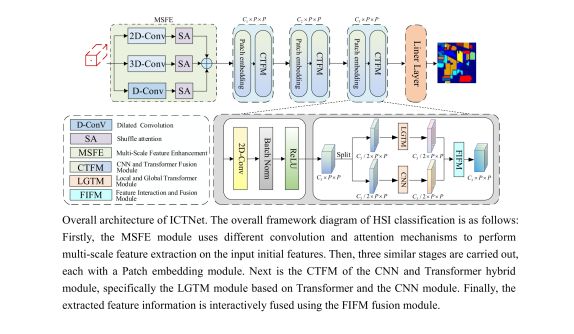
| The classification of a hyperspectral image (HSI) plays a critical role and serves as the foundation for many related applications. The combination of convolutional neural networks (CNNs) and transformers has shown promising performance in HSI classification by using the advantages of the two networks. However, existing hybrid models often offer limited feature interaction and fusion between the two branches. Here, a novel interactive convolution and transformer network (ICTNet) for HSI classification is proposed. | |
Localized Brightness–Shape–Moisture Soil Parameterization for Improved PROSAIL-5 Canopy Simulation*
Wessel Bonnet, Moses Azong Cho, Paxie W. Chirwa, and Cecilia Masemola
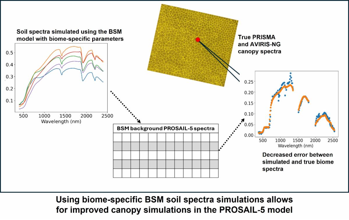
| The mapping and modeling of canopies is important for the understanding, monitoring, and management of vegetation systems. To effectively model or simulate canopy spectra at the hyperspectral level, background soil spectra must first be simulated accurately. Spectrometer data simulation such as this will become increasingly relevant as newer imaging spectroscopy missions, such as PRISMA and AVIRIS-NG start to produce more data sets. In this study, the brightness–shape–moisture (BSM) radiative transfer model (RTM) with localized parameter distributions was used in conjunction with the PROSAIL-5 RTM to simulate canopy spectra for different biomes in the semiarid regions of Southern Africa as captured with PRISMA or AVIRIS-NG sensors. | | | | |