|
- Mark Your Calendar for WalkWorks Webinar on Sidewalks
- Funding Spotlight: The Multimodal Transportation Funds (Plural)
- Upcoming AT Events: Regional, National, and Global
- Week Without Driving Awards, Survey, Debrief, and Looking Ahead
- WSJ Analysis of Pedestrian Death Sheds Light on Visibility on Stroads
- Active Transportation Resources: Mapping & Analysis, Near & Far
- What's In a Word? Park Once District
- Infrastructure Insights From the Interwebs
| | |
Sidewalks are one of the top active transportation concerns both for municipalities and for advocates. We field many questions and concerns about them, not least among them, interest in how to fund them, as they are typically the responsibility of the adjacent property owner and therefore often in deplorable condition – with little hope of improvement in the offing. To help address questions about how to evaluate, plan for, and make meaningful progress on provision of safe and accessible sidewalks, WalkWorks is putting on a webinar on the subject on Wednesday, December 9, from 2 to 3:30pm.
The "Sidewalks of PA" webinar brings together examples of sidewalk assessment strategies, one crowd-sourced and volunteer-based and the other a professional service provided for a fee, and matches that information up with examples from two communities that have run successful sidewalk investment incentive programs in recent years. Finally, it introduces strategies to ensure that a commitment to sidewalk maintenance is compatible with maintaining street trees. Presenters include: Seth Bush, Safe Sidewalks Crew; Patrick Nealon, Precision Infrastructure Management; Cindy Wells, Union City Borough Manager; Eden Zenisek, Indiana Borough Grants Manager; and Vinnie Cotrone, Urban Forester with PSU Extension. Hopefully the resulting program will help clarify what can often be a confusing and overwhelming topic. Perhaps we can work together to make the case for some dedicated state funding structured to enable more communities to put such programs into place – imagine something that parallels the DCED Facade Improvement Grant Program which provides funding to Main Street organizations to be awarded in turn as matching funds for individual property improvements in accordance with locally determined guidelines?
| | |
In the meantime, let’s consider funding programs that already exist. Here are two that might make you think you’re seeing double. It is not your imagination, there are Multimodal Transportation Funds available through two different state agencies. These funds came into existence through Act 89 of 2013, providing funds to both the DCED Commonwealth Finance Authority (CFA) and PennDOT, through which “$35 million is allocated to highway- and bridge-related projects, while… $5 million is available for projects that propose improvements to any mode.” They can be used for similar projects, with their grant amounts having been brought into alignment in recent years, but they do have different guidelines, schedules, review processes, and administration.
The PennDOT Multimodal Transportation Fund may be top of mind as applications for it are due this week on October 30. Municipalities are eligible to apply for transportation-related projects “that enhance communities, improve pedestrian safety, and/or revitalize transit,” most frequently sidewalks for pedestrians along key corridors as part of larger community streetscape/placemaking improvements. But they may also include bike infrastructure and transit, whether bus, or rail, or even freight rail crossings. Projects can range from $100k total cost to $3M maximum grant award, with a required match of 30%. Municipalities, Councils of Government, businesses or non-profits, economic development agencies, transit agencies, and port or rail/freight operators are all eligible applicants, but there are more extensive financial obligations placed on non-municipal applicants and since the projects much be completed on a reimbursement basis, it may be challenging for some entities to manage The funding can be used to cover some professional services (up to 10% of the award) and land acquisition.
The DCED version of the Multimodal Transportation Fund is due at the end of July. The guidelines have largely been aligned with the PennDOT ones, but with some deviations, such as not including criteria for the selection of contractors from a pre-approved list (PennDOT requirement, not DCED) and a couple of the eligible uses (DCED disallows parking lots and security cameras except as part of a larger transportation project) and the financial burden for non-municipal applicants and the reimbursement process. Both do require prevailing wage. Because of the differences, the DCED fund may be more appropriate for a non-profit or business applicant.
| | |
Mark your calendar now for various November events, some recurring and some one-off and new. Check out these opportunities. If you aren’t ready for them this year, think about whether this constitutes suitable notice for participating next year. And if you’re not in the region where the first one listed is taking place, consider whether there should be a similar initiative in your region:
-
11/12 – South Central PA Trails meeting, PA Farm Show Complex, from 9 to 3 (plus virtual option) – register here to attend (both in person or remote) this follow-up to an initial regional trails workshop held back in June, which looked at the need and potential for regional coordination along the lines of the very successful Circuit Trails work happening in the Philadelphia region.
-
11/14 (11/18 observed) – Ruby Bridges Walk to School Day – since the official anniversary marking the day 6-year-old Ruby Bridges integrated her school in New Orleans in 1960, local observances will be on other days during the school week, e.g. W, 11/18; the national Safe Routes Partnership has an extensive library of resources assembled for this, possibly more than on the main landing site.
-
11/15 – World Day of Remembrance – an occasion to honor the more than 1M annual global deaths and countless more people injured or otherwise impacted by traffic violence; look for an event near you; organize an event if you don't have one; consider those lost in your community and your circle.
| | |
The official Week Without Driving for 2026 is done. One follow-up from the national Nondrivers Alliance organization this year was the recognition of a number of elected officials with superlatives. It is notable that while the total number of sign-ups in PA this year increased by a factor of 10 to over 200, the number of people who indicated they were elected officials merely doubled to 2! Perhaps it is too much of a commitment for people or something they feel would be too risky in the event that they aren’t able to accomplish it? It must be acknowledged, after all, that participating in WWD can be a challenge, one that puts us in mind of the ongoing challenges of everyone living in car-dependent places and of non-drivers living in a car-oriented society.
The dates for the 2027 observance have already been set. Mark your calendar for Thursday, September 30, to Wednesday, October 6 (yay, an actual week; no, not starting on a Sunday or Monday – consider using the first part of the week for last minute kick-off and pre-game events). Meanwhile, there is a survey circulating, which people are invited to complete about WWD – whether or not you participated (also some incentives to respond, you could win a gift card…) – by November 20. There will also be a WWD PA debrief held on zoom on Thursday, November 5, at noon.
We know we still need sustainable funding for transportation here in PA and it’s going to be the big, and urgent, push for the coming legislative session. In theory the experience and reality of WWD to help make the case for understanding transportation needs more expansively across the state, as including significant numbers of non-drivers everywhere – and recognizing that the habit of simply opting for highway expansions is not a recipe for congestion reduction in the long term? Be sure you’re signed on with Transit for All PA – yes, especially those of you for whom participating in WWD is unimaginable – that’s the point! We all need transportation options, not to be trapped or limited in any circumstances under which we don’t have access to a car, whether age, disability, medical interlude, lack of access to a vehicle, or lack of ability to maintain and operate such a vehicle. It costs $5k annually per vehicle to own and operate in PA. We have data showing that those costs are remarkably consistent across all 67 counties – and yet, household incomes vary widely, with that $5k/vehicle, with the average two vehicles (or more) per household, putting a major strain on most households in many counties… It lends a bit more detail to the Housing + Transportation Index.
| |
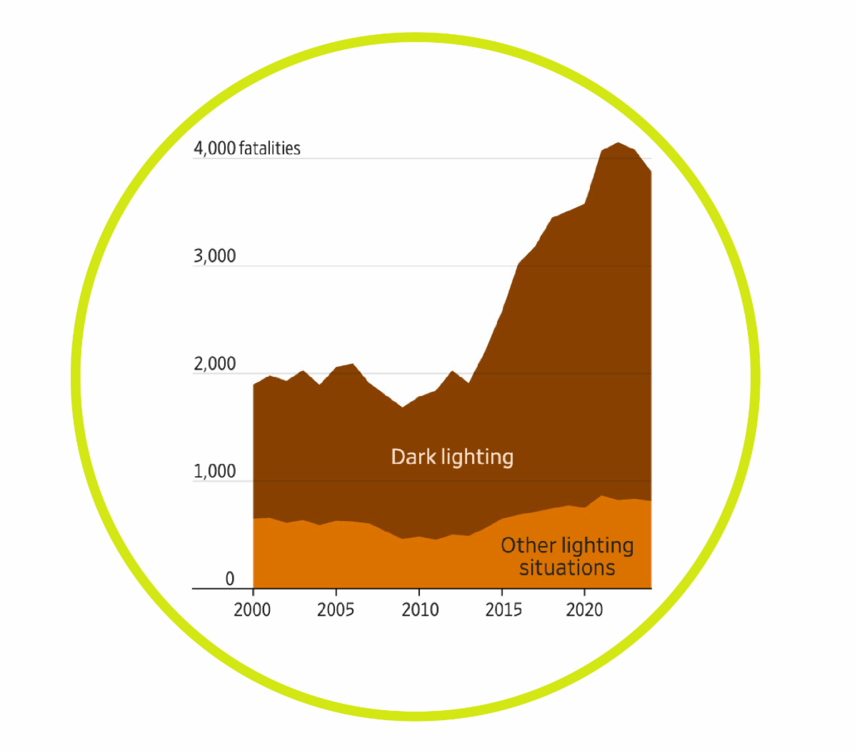
 | | The Wall Street Journal (may be paywalled, was alternately accessible and inaccessible over the past week...) took on the subject of road safety and made a meaningful contribution to crunching the numbers, prompted by yet another pedestrian death on a stretch of road in Memphis, TN, that has seen many in the past few decades. In the process, WSJ writers focused in on the nature of the most dangerous typologies of roadway in the country – those described as “stroads,” combining the frequent destinations of a street with the vehicle throughput, high speeds, and wide widths more associated with a long-distance road. These are often in sprawling sections of cities, beyond what was the edge of the historic town, but not out in the countryside. They feature stores, restaurants, and professional offices. And they often divide people on one side of the road from what ought to be a continuation of their neighborhoods on the other side. It is worthwhile to have this august newspaper introduce the concept of the stroad to new audiences, giving credit to Strong Towns founder Chuck Marohn who coined the term 15 years ago.
To better understand the crash, the journal looked at the long-term pedestrian crash data for the corridor in question and other similar roads around the country and teased apart information about the likelihood of deadly crashes for pedestrians taking place in locations with poor lighting. While this is one of the top "proven safety countermeasures" recommended to improve ped safety, the WSJ analysis shows that while dark conditions are and have been more dangerous than light for other roads, the hazard has increased far more on stroads. This is very helpful in identifying appropriate safety improvements depending on the land use context.
The documentation the paper provides is revealing in ways that the authors did not address, specifically the nature of the dangerous choice of a "mid-block" location to cross. The location of the deadly crossing analyzed was at a nominally “mid-block” location a substantial distance in either direction from intersections with pedestrian signals and crosswalks – and yet, it was actually also at an intersection with a side street, so not literally "mid-block" but rather between signalized marked crossings. It was clearly along an entirely rational and even reasonable route between destinations. Further, the record of pedestrian injuries and deaths at the more distant intersections in question were such that the road presented a hazard no matter where the pedestrian chose to cross. "To walk on Union Avenue feels like you are about to be killed." Indeed.
While not part of the article, the implication is that speed continues to be a decisive factor in such deadly crashes (along with changes in vehicle design, hood shape, and weight). Perhaps the lesson to be taken from roads being uniformly more dangerous at night and stroads in particular is that drivers should be trained about and expected to adjust their speed downward to reflect their loss of visual acuity at night impaired as their sight is by the vehicle itself as well as the darkness.
| |
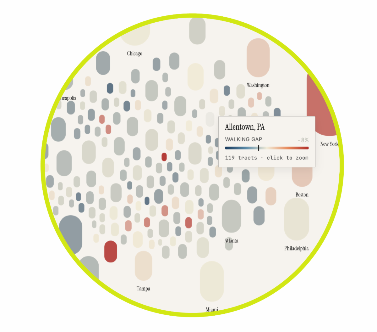
| | | WalkWorks maintains a list of Active Transportation-Related Mapping Resources on an ongoing basis. Not every link on the list is relevant or particularly telling for every community, but they are useful for compiling a series of data-based geographic snapshots of a place, from which some initial observations can be made, assumptions can be confirmed or refuted, and avenues for further inquiry can be determined. In some cases, pretty much any address can be looked up, while others have a narrower geographic or categorical focus. But even when a given map is not directly available for a community, the principle behind the map may be illuminating. That’s the case with a new map that looks beyond the initial number generated by the WalkScore algorithm and compares that to indices of actual active travel behavior. Some WalkWorks grantees and various communities in Pennsylvania do show up on the new map. And even for those that don’t consider what the image might imply for your community. Be careful not to confuse this new National Walkability Atlas with the far less nuanced (but more extensive) National Walkability Index from the US EPA.
WalkScore was originally an academic endeavor and was bought up by a commercial real estate concern about 20 years ago. It is already pretty variable, providing a lot more information, including walkability heatmaps, transit and bike scores, in some areas and just blanket numerical scores in others. Even with its limitations ultimately it has been an interesting but crude measure of a general level of access, i.e. proximity and density of key destinations, like schools, banks, stores, etc. It does not include any assessment of the type or condition of the infrastructure connecting those places. In other words, there could potentially be key destinations, but no sidewalks or no useable ones. To help address that, a new research project compares the WalkScores with anonymized cellphone data on actual walking and indicates where there is more walking than the WalkScore would predict and where there is less in 272 different urban areas. The key factors do seem to be contextual, street form, land use, and degree of network connectivity. Places with colleges and universities tend to show more walking than expected, whether Charlottesville, VA, or Boulder, CO, as well as ur-walking cities like NYC or New Orleans. Other places, like Philadelphia and Chicago, exhibit less walking than might be expected. That said, you can view individual urban areas and zoom in on different sections to see their scores and the actual city/county of PHL shows more walking, but the score for the urban area overall is pulled down by the far less foot-traffic-amenable surrounding areas in PA, NJ, and DE.
| | |
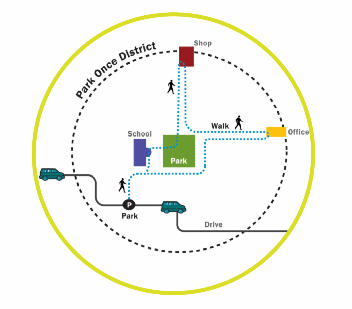
A park once district is a place where people who arrive in a motor vehicle are expected, guided, encouraged, incentivized, and/or required to walk from one internal destination to another after parking rather than repeatedly returning to their vehicle and moving it a short distance to a new parking space in the district.
Taking a park-once approach is essential to realizing the active travel and road safety potential of destinations frequented by people in cars. Park once districts reinforce the reality that everyone is a pedestrian for some portion of their trip.
The most lively destinations and economic centers have been doing this for a long time though perhaps without much thought to the concept -- it would have just long been part of the inherent structure of the best downtowns. But much of the country has spent the past 70 years tearing down historic urban fabric to replace buildings with surface parking lots, creating the opposite of park once areas. In many cases, the zoning code and parking minimums established for different uses has required this. In order to make good town planning legal again, municipalities across the country (and across the commonwealth) are removing parking minimums or at least shifting them to maximums, as documented by the Parking Reform Network and encouraged by Strong Towns.
The Reinventing Parking Podcast tends to refer to the park once concept as walkable parking – but it’s really walkable places, with parking dispersed and cost structures designed to encourage pro-social, pro-community, pro-economic activity walking between local destinations.
Park once districts encourage walkability for visitors as well as residents, meaning that just because most people in the US do not currently live in walkable communities, doesn't mean they don't have access to the experience of walkability. This is one of the keys to cracking the code of participating in Week Without Driving for people whose homes or offices are in entirely car-dependent locations. People could get creative and consider whether there are any Third Places they frequent that might have other destinations nearby that they could trip-stacking by walking to. If you can’t walk or bike or take transit between home and work, could you create a hybrid commute and drive to a bike trail and then go the last few miles by bike? Could you drive to (or near to) a favorite/regular destination and then walk to a couple other places from there before returning to the car? And can you do this without consigning yourself to hiking across massive parking lots between big box stores?
Park Once Districts seem to be attributed to the enlightened traffic engineer, Walter Kulash, with Glatting Jackson out of Orlando, FL, who was promoting Traditional Neighborhood Development, park once districts and other New Urbanist principles before the Center for the New Urbanism was founded (as in the early 1990s) and urging the design of places for humane transportation.
Park once as a dictum can translate to remote parking, but not in the sense of vast distant lots and shuttles at theme parks or airport; it may only be remote in that it is not directly on the property of a given business, but is instead pooled in the neighborhood, with public parking either on-street, in lots, or in structures provided en masse, not property by property or use by use. Think of the parking lots all marked as being only for the use of a specific business. That is an inevitable outgrowth of parking minimums. It is counterproductive. It makes visitors less likely to spend more money in passing on a visit to an area and more likely to spend more time moving a heavy and dangerous vehicle around on the roads of the district thereby further depressing the walkability of the area for others.
On-street parking spaces that are signed to indicate that they are reserved for visitors to specific businesses are even worse. This is a sign that a community has a serious walkability problem.
| | |
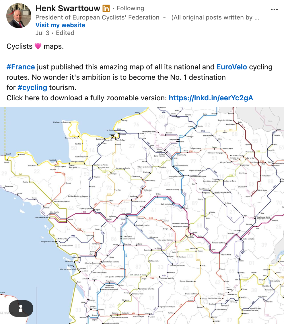
Not Just Paris!
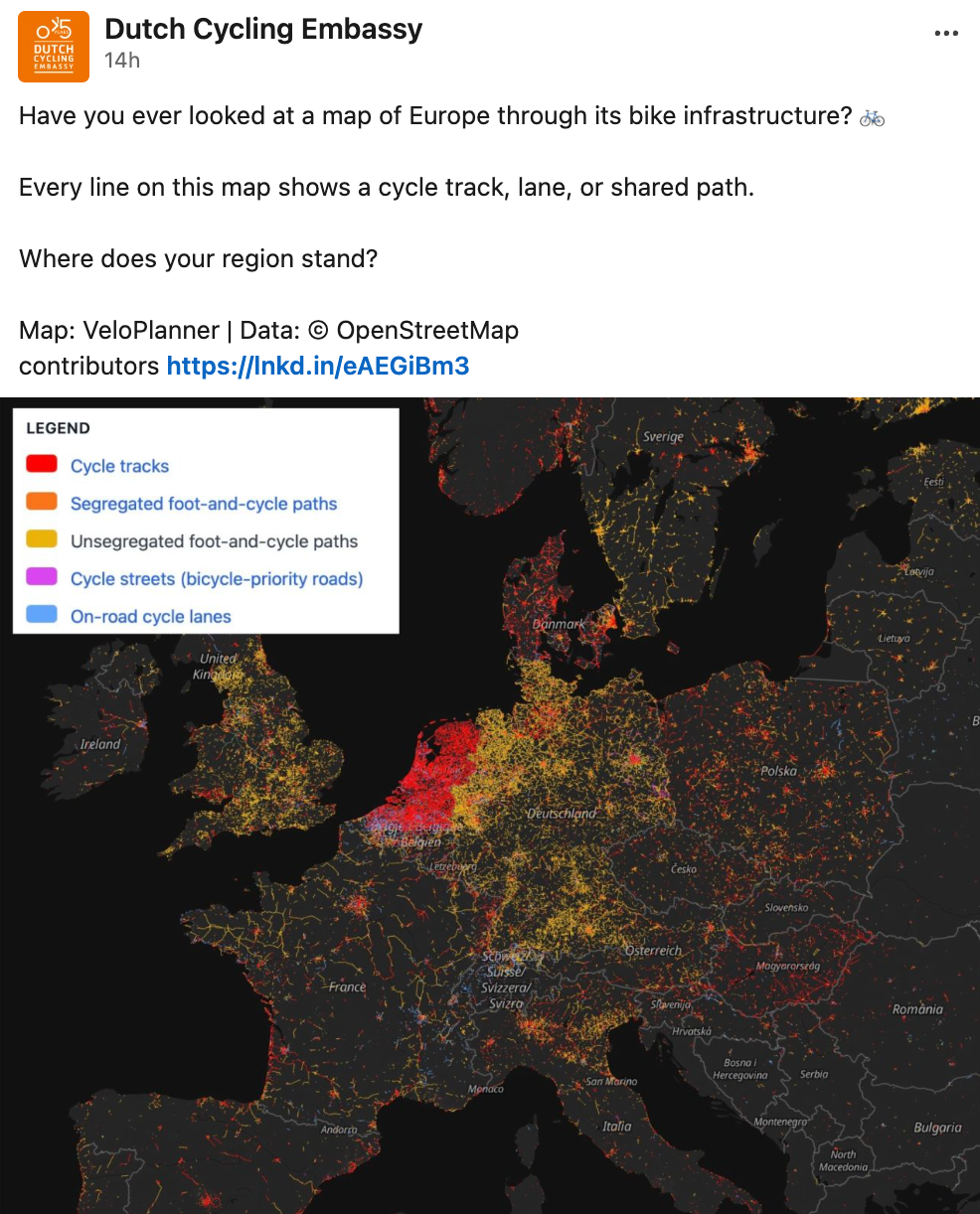
Admittedly not all the news out of France is great these days, but this is an optimistic and encouraging sight. The "Hexagon" is covered by a network of routes which could -- in combination with the culinary offerings -- make for a very in-demand cycling destination
| | |
Not So Fast!
This astounding map shows how far France still has to go, even with the food as a massive additional draw, in comparison to the sheer volume and extent of cycling infrastructure in the Netherlands. The best stroop waffles can't hold a candle to everyday fare at a French cafe, but honestly, it's the network, stupid!
| | |
PA Walkworks | Website
Reading a forward? Sign up for the newsletter here.
Have a comment, suggestion, or content for the newsletter? Submit it here!
| | | | | |