From One Extreme to the Other

Updated June 17, 2026 at 3PM Eastern

Good afternoon, folks! If we rewind the tape to about a month ago, 42% of Kentucky was classified in extreme drought according to the U.S. Drought Monitor. To find the last time the state had more extreme drought coverage, you have to go all the way back to 2007. That year was one of the more severe droughts we’ve seen over the past couple of decades, so it’s understandable that concerns were growing about another major drought in 2026.


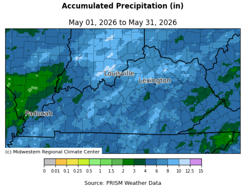
That said, more often than not over the past decade, our dry spells have been relatively short-lived, as our wetter climate always tends to win out. It took a bit longer for that transition to occur in 2026, but the tide has finally started to turn over the past month. Following an active stretch between May 18th and 26th, Kentucky officially averaged 5.34 inches of precipitation for the month of May, fairly well distributed across the area (map below). This marked the first month with above-normal rainfall since October. Outside of a few sporadic dry pockets, most areas picked up at least 4 inches for the month.

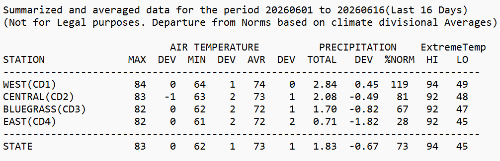
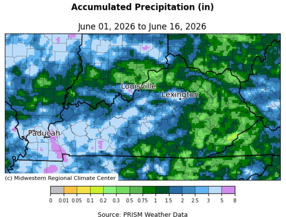
That said, the first half of June has been much more split. Since the start of the month, data from the UK Ag Weather Center shows the state has averaged 1.83 inches, but there’s been a noticeable divide from one side of Kentucky to the other. Western Kentucky has averaged 2.84 inches since June 1, while Eastern Kentucky has only picked up 0.71 inches (data and map below). Taking a closer look locally, the Marshall (5.04 inches) and Logan County (5.65) Kentucky Mesonet stations have already surpassed their normal monthly rainfall for June, and we’re only halfway through the month. On the other hand, Letcher and Knox counties have recorded just 0.14 and 0.25 inches, respectively. For reference, normal precipitation for June sits at 4.72 inches.

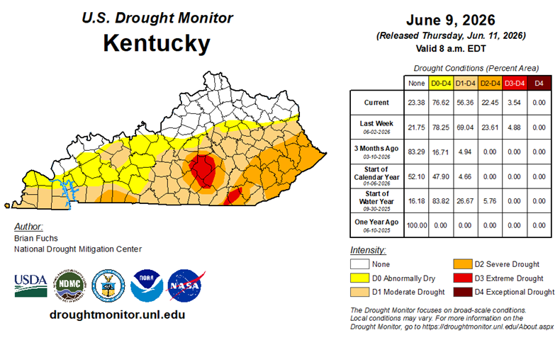
Put it all together, and as you can imagine, drought conditions have improved across much of the state. Below is the latest update from the U.S. Drought Monitor. Following a peak of 42% of Kentucky in the extreme drought category on May 19th, only 4% of the state remains in that category. Many areas across Western and Central Kentucky have seen improvements of two to three categories.


That said, not everyone has benefited equally. With lower rainfall totals across Southeastern Kentucky over the past month, drought conditions there have remained relatively unchanged, with much of the region still in severe drought. Similar to recent updates, these conditions are largely being driven by lingering long-term dryness, which continues to show up through hydrological impacts across the state. While we have seen some passing signs of short-term agricultural drought, the bigger issue this year has been persistently low farm ponds, lakes, and reservoirs.


Even with the wetter pattern in May, 2026 still ranks as the ninth driest January through May on record, going back 132 years. Through May, the state has averaged just 15.47 inches of precipitation, about 6.5 inches below normal. For comparison, 2025 was the wettest January to May period on record, with an average of 31.62 inches.


Many are already aware, but as a reminder, if any portion of a county is classified in the extreme drought category on the U.S. Drought Monitor, livestock producers in that county may be eligible for financial assistance through the USDA Livestock Forage Disaster Program.


As of June 17th, 64 counties in Kentucky have met that threshold, meaning producers may be eligible for three or more monthly payments. In counties where extreme drought conditions have persisted for at least four weeks, producers may qualify for four monthly payments.


While additional eligibility requirements do apply, these drought designations represent an important first step in the assistance process. Producers should continue to monitor these designations and be prepared to document livestock inventories if and when they become eligible. Specific questions about the LFP program should be directed to your local FSA office.

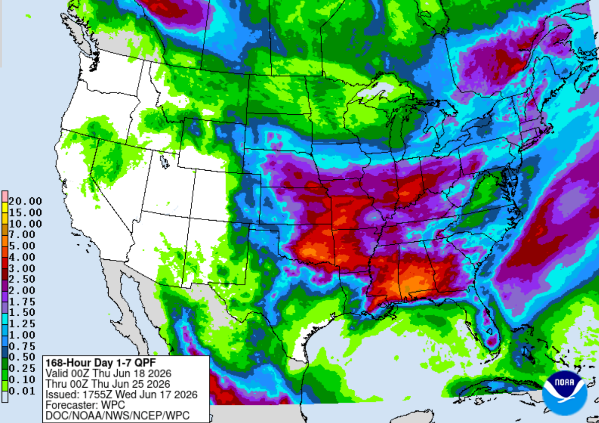
Lucky for us, the wet pattern looks to continue. Another healthy dose of precipitation is on the way, starting tonight and lasting through Thursday, followed by another round Sunday into next Monday. While there is still plenty of uncertainty in exact totals, the Weather Prediction Center is painting a pretty impressive picture (below) for widespread rainfall. Rather than focusing on specific amounts, the takeaway is that much of the state should see a meaningful round of precipitation over the upcoming week.


Keep in mind that this first round will also bring the possibility of severe weather.

Currently, most of the area is under a slight risk for severe storms from the Storm Prediction Center for tonight and tomorrow, with damaging winds as the main threat. The higher tornado risk is expected to stay farther north into Indiana and Illinois, but some spin-ups can't be ruled out.


In addition, much of the northern half of Kentucky is under a Flood Watch. With localized rainfall amounts potentially reaching 3 inches, we could see some isolated flash flooding issues develop.


As always, below are links to forecast briefings from each National Weather Service office across Kentucky for more information:


Western KY - NWS Paducah, KY


Central KY - NWS Louisville, KY


Eastern KY - NWS Jackson, KY

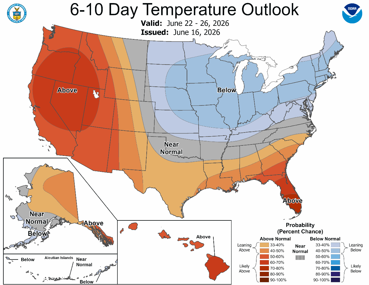
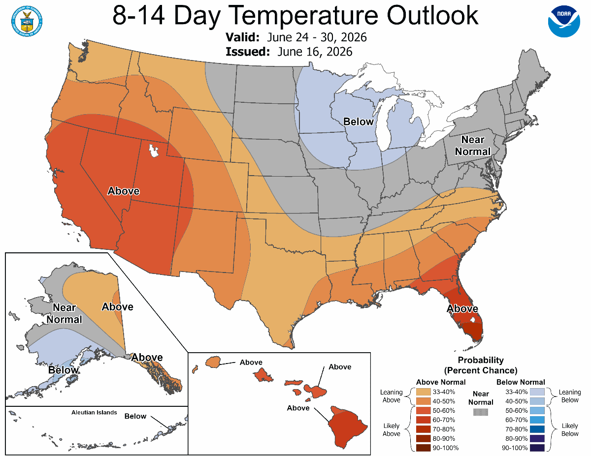
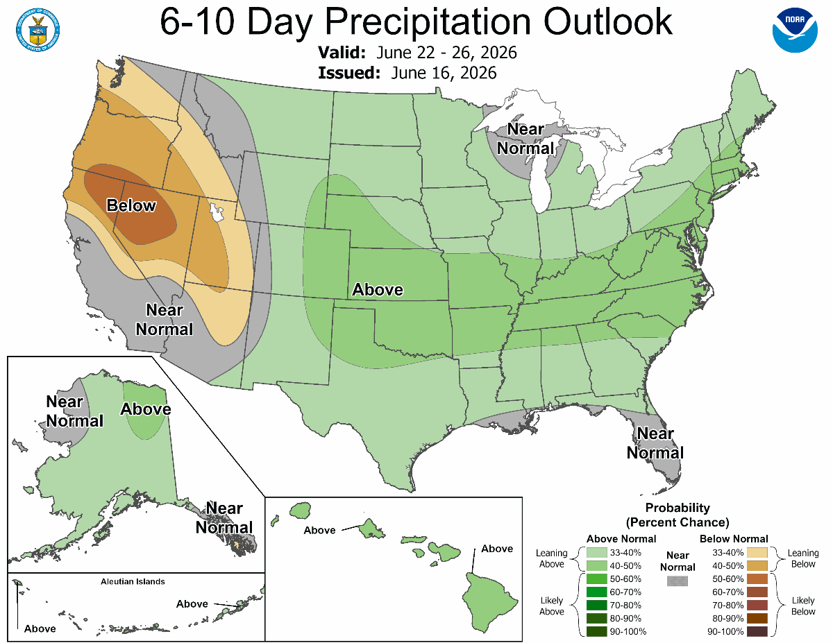
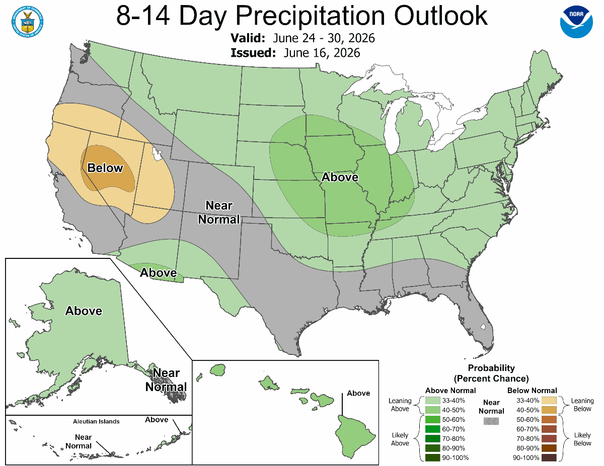
From there, outlooks lean toward better odds for above-normal precipitation and below-normal temperatures through the end of June (maps below). Normal highs for the second half of the month typically run in the mid to upper 80s across Kentucky, while lows average in the mid to upper 60s. All in all, the sweltering heat and humidity look to hold off a while longer.


Forecast confidence drops off quite a bit beyond that, but I do want to briefly touch on something that’s been getting a lot of attention lately. There has been quite a bit of talk about El Niño and its potential impacts this summer. El Niño is a large-scale climate pattern driven by warmer-than-normal sea surface temperatures in the equatorial Pacific Ocean, which in turn can influence the average position of the jet stream, or our main storm track.


The latest outlook suggests El Niño conditions will strengthen as we head into fall and winter and could end up being one of the stronger events on record. That said, El Niño typically has very little influence on our weather patterns during the summer months here in Kentucky. If anything, the more noticeable impacts tend to show up later in the year, with a tendency toward reduced hurricane activity in the Atlantic during the fall and a drier signal at times in the winter. As always, every El Niño is a bit different in how it plays out, but the main takeaway is that it's unlikely to have much impact on what we experience here in Kentucky over the remainder of the summer.


Until next time!

Related News from UK and Beyond

Kentucky Field Crop News - UK Martin-Gatton CAFE Grain and Forage Center of Excellence, June 2026


Kentucky Pest News - UK Extension Entomology, Plant Pathology, and Weed Science Specialists, June 10, 2026


Kentucky Fruit Facts - May/June 2026 Edition


Kentucky Beef Cattle Newsletter "Off the Hoof" - Beef IRM Team, June 2026


Kentucky Forage News - June 3, 2026


STAY CONNECTED

Email  Twitter  Web